-
Membership
Membership
Anyone with an interest in the history of the built environment is welcome to join the Society of Architectural Historians -
Conferences
Conferences
SAH Annual International Conferences bring members together for scholarly exchange and networking -
Publications
Publications
Through print and digital publications, SAH documents the history of the built environment and disseminates scholarshipLatest Issue:
-
Programs
Programs
SAH promotes meaningful engagement with the history of the built environment through its programsMember Programs
-
Jobs & Opportunities
Jobs & Opportunities
SAH provides resources, fellowships, and grants to help further your career and professional life -
Support
Support
We invite you to support the educational mission of SAH by making a gift, becoming a member, or volunteering -
About
About
SAH promotes the study, interpretation, and conservation of the built environment worldwide for the benefit of all
2018 Edilia and François-Auguste de Montêquin Junior Scholar Fellowship Report
Dates: July–September 2018
Locations: Cuzco, Urubamba Valley, Ayacucho (all in Peru), Lake Titicaca Basin (Peru and Bolivia)
Historical Background
The trans-Atlantic encounter is often veiled in the popular narrative of a handful of men whose journeys trigger a ripple effect that forever changed both worlds on either side of the ocean. Whether the main characters are portrayed as daring adventurers or as religious fanatics, the Europeans remain the central agents in the process. When Francisco Pizzaro reached Tahuantinsuyu, the land of the four quarters bound together as the Inca called their empire, they found a land devastated by civil war and ready for the taking. European disease outpaced its human carriers and after the Inca ruler Huayna Capac fell to it, his sons, Huascar and Atahualpa, engaged in a war of succession that paved the way of Spanish invasion in the Andes. Although critical, this conflict is still severely understudied and poorly understood.
Building was one of the most significant expressions of Inca power and a ruler’s success was measured by his construction prowess. In order to secure his legitimacy, Huascar initiated a number of building projects during the civil war, including two royal estates, Calca and Kañaraqay. These private complexes were an important tool for Inca rulers for inscribing their opinions on political and religious, as well as personal, matters onto the landscape. While Calca sits among the estates of Huascar’s predecessors in the Urubamba Valley, Kañaraqay (Figure 1) is located at the opposite end of the Inca heartland. Consummately losing the civil war to Atahualpa’s forces, who controlled the northern part of the empire, Huascar constructed Kañaraqay partially to fulfill his duty as a ruler and partially in order to enlist the southern part of the empire to his cause in the war. Sitting across lake Muina from Pikillacta (Figure 2), a major center of the Huari empire (600–1000 CE), and referring to Tiahuanaco (400–1000 CE) and Lake Titicaca Basin architecture, the estate acted to secure his political legitimacy both through the act of building and as well as this association with the old seats of power in the Andes.
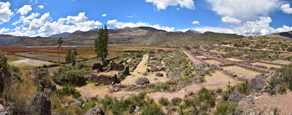
Figure 1: Huascar’s royal estate Kañaraqay in the Lucre Basin, Peru. Photograph by author.
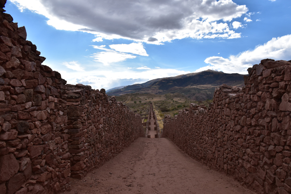
Figure 2: One of the major Huari satellite cities, Pikillacta is the main Huari site in the Inca heartland. Photograph by author.
With the support of the Edilia and François-Auguste de Montêquin Junior Scholar Fellowship, I travelled to the Urubamba Valley (Figure 3) in Peru in July 2018 in order to conduct a comparative study of the site of Kañaraqay in relation to the other Inca royal estates. I further travelled to the Lake Titicaca Basin (Figure 4) in Peru and Bolivia in August 2018 for a similar comparison between Huascar’s estate and the Inca installations on the lake in relation to Tiahuanaco architecture.
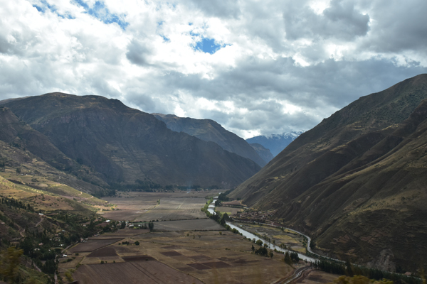
Figure 3: The Inca rulers chose the Urubamba (or Vilcanota) Valley as the site for their spectacular royal estates. Photograph by author.
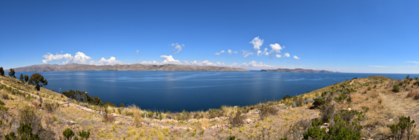
Figure 4: The highest navigable lake in the world, Lake Titicaca is the cultural center of the southern quarter of the Inca empire and the Tiahuanaco heartland. Photograph by author.
Inca Royal Estates
Before the outbreak of the Inca civil war, three rulers had constructed royal estates—Pachacuti built at Pisac, Ollantaytambo, and Machu Picchu, Topa Inca settled at Chinchero, and Huayna Capaca constructed Quispiguanca. All of these retreats are located in the pleasant Urubamba Valley (now referred to as the Sacred Valley of the Inca) at a lower elevation than the Inca capital Cuzco. I started my journey at Pisac, where the valley widens and allows for agricultural production, and travelled for two weeks northwest to Ollantaytambo (Figure 5), where the hill close in on the river again. Tourists today rush through these sites in a day or two, but this time frame allowed me to visit the royal estates as they were meant to be experienced—on foot, tediously climbing, following the natural landscape, and constantly hiding or revealing breathtaking vistas and charged spaces.
Pisac sits some 500 m (or 1600 ft) above the valley hugging the hills with its exquisite terracing (Figure 6), while its grand storehouses perch high above the valley (Figure 7). The two-hour strenuous hike repels most tourists, depriving them of the corporeal experience on which the meaning of the site is built. Similar to Machu Picchu (where the four-day trek is still popular), Pisac’s significance lies in its entanglement with the natural environment. Pachacuti’s estates were built at a time of initial expansion of the empire and are characterized by a preoccupation with professing the legitimacy of Inca dominion. Natural features and especially rock outcrops were seen as potent active agents through the live-giving essence called kamay. Pachacuti’s architectural language attempted to enter into a complementary relationship with this potent landscape through outcrop integration (Figure 8) naturalizing the legitimacy of Inca colonization.
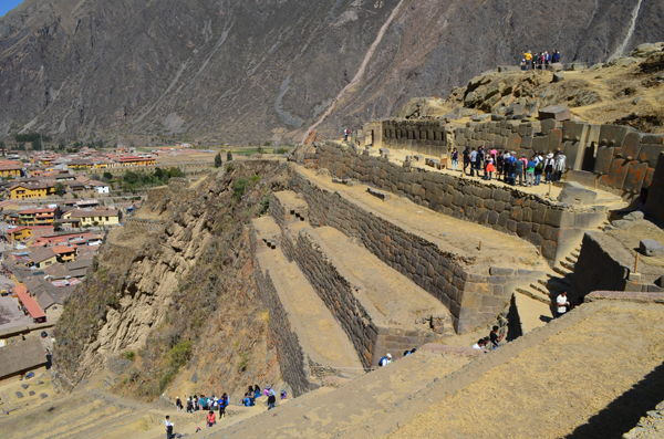
Figure 5: Pachacuti’s royal estate at Ollantaytambo, Peru. Photograph by author.
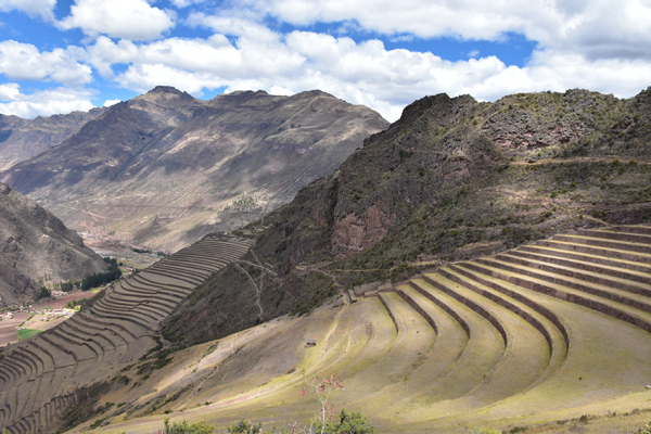
Figure 6: Agricultural terraces at Pachacuti’s estate at Pisac. Photograph by author.
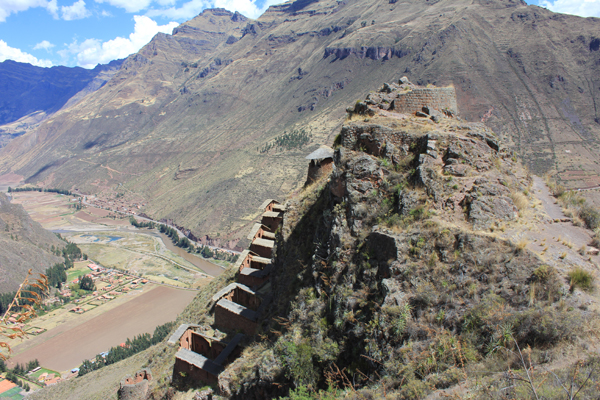
Figure 7: Adobe storehouses at Pachacuti’s estate at Pisac. Photograph by author.
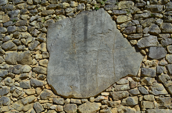
Figure 8: Rock outcrop integration at Pachacuti’s estate at Machu Picchu. Photograph by author.
By the time Pachacuti’s son, Topa Inca, constructed his estate at Chinchero, the empire had grown immensely. Its focus was, thus, not on imperial legitimacy but on a private matter of imperial proportions. Located a day’s trip from the valley and at the birthplace of his son, Capac Huari, Chinchero expressed Topa Inca’s controversial choice of successor. The journey up the mountainside from the Urubamba culminated in a grand plaza (Figure 9) that professed the greatness of Topa Inca to everyone who might have felt any sense of accomplishment at the end of the steep staircase climb.
Despite Topa Inca’s choice of Capac Huari, he was eventually replaced with Huayna Capac who throughout of his career had to face the fact he only ruled because of the power of his mother. This complex predisposed the radical change in his architectural language at Quispiguanca, which focused on the man-made and used adobe as main material. Adobe made the exaggerated four-story high palace with triple-jamb doorways (Figure 10) possible, exhibiting the shift in the built environment from complementarity with the landscape to self-reference.
During the civil war, Huascar again faced concerns about his personal legitimacy. Perhaps due to the devastation of the war and the unavailability of some of the best Inca craftsmen and engineers, his adaptation was different from his father’s attempt at monumental grandeur. Instead, Kañaraqay deviated from the rural royal estate form and was constructed adjacent to the principal town of the Muina ethnic group in plain sight from Pikillacta. Although Huascar used form similar to that of his predecessors—for example, rock outcrop integration (Figure 11) and terracing (Figure 12)—his estate showcased its patron’s relationship with history.
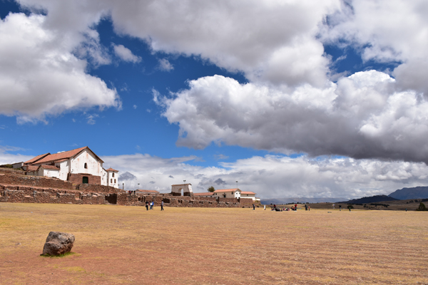
Figure 9: The main plaza of Topa Inca’s estate at Chinchero. Photograph by author.
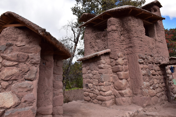
Figure 10: Triple-jamb doorway at the main palace of Huayna Capac’s estate at Quispiguanca. Photograph by author.
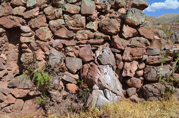
Figure 11: Rock outcrop integration at Huascar’s estate at Kañaraqay. Photograph by author.
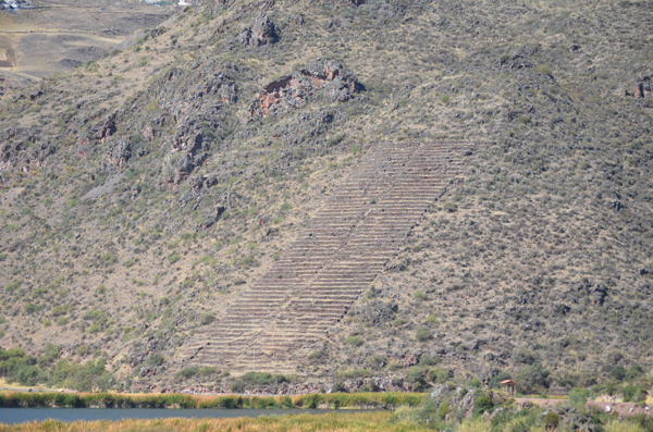
Figure 12: Terraces at Huascar’s estate at Kañaraqay. Photograph by author.
Inca Architecture on Lake Titicaca and Huari and Tiahuanaco
Huari and Tiahuanaco were the two large Andean empires on which Huascar attempted to construct his long-term claim. Other than Pikillacta, I also visited the Huari capital near Ayacucho in Peru, and I travelled along the Lake Titicaca coast for two weeks between Puno in Peru and the Islands of the Sun and Moon in Bolivia in the Tiahuanaco heartland. It is unclear whether Huascar understood that these were distinct past empires or whether he conflated them into a single entity, but he borrowed from both at his estates. Many Inca settlements follow a loosely defined grid plan, which is a function not of planning, but rather of the signature Inca enclosures, called kancha, that are rectangular in shape following the rectangular buildings. At flat terrain, kanchas naturally form right angles and straight streets between them, but this seemingly orthogonal plan breaks down to accommodate topography. The only places where the Inca seem to have purposefully kept the orthogonality of their site planning are located in the Lake Titicaca Basin. This is the case at Hatuncolla as well as at Chucuito, where the plan radiates slightly from a central plaza. At the same time, Tiahuanaco seems to have grown organically. The Huari case is similar, as none of the sites in the Huari heartland seem to be planned, but Pikillacta, as well as other satellite cities, are carefully laid down.
Both of Huascar’s estates seem to be orthogonally planned. Not much is left of Calca today, but the village’s grid is certainly based on its original Inca plan (Figure 13). Kañaraqay, a stone’s throw from Pikillacta, had a much more obvious example to follow. Its carefully laid down three rows of identical buildings separated by two large avenues clearly reference the order of the past that Huascar looked to reinstitute.
Much more work remains to be done on all of the participants of this story. The civil war and its effects, both in its built environment and in its social and political manifestations, are still poorly understood. The support of the Edilia and François-Auguste de Montêquin Junior Scholar Fellowship was instrumental for my research on Huascar’s royal estate at Kañaraqay, promising exciting new insights into the catastrophic war of succession, the enigmatic final Inca ruler, and the role of architecture in political legitimacy in the time of conflict.
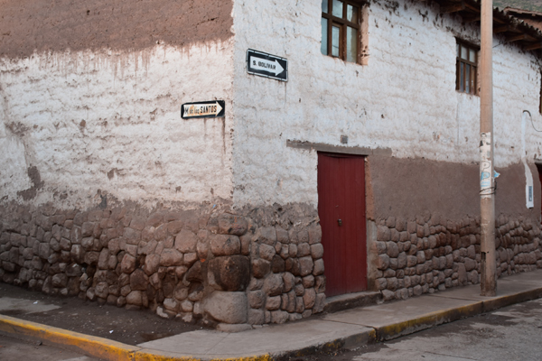
Figure 13: Remains of Inca wall base from Huascar’s estate at Calca. Photograph by author.

Leave a commentOrder by
Newest on top Oldest on top