-
Conferences
Conferences
SAH Annual International Conferences bring members together for scholarly exchange and networking
-
Publications
Publications
Through print and digital publications, SAH documents the history of the built environment and disseminates scholarshipLatest Issue:
-
About
About
SAH promotes the study, interpretation, and conservation of the built environment worldwide for the benefit of all

On Form: Infrastructuralism and the Schutzgebiet
Jasper Ludewig is a 2023 recipient of the H. Allen Brooks Travelling Fellowship. All photographs are by the author, except where otherwise specified.
I finally find it in dappled light under a tree in Blohms Park, west of the city center. I am in Hamburg, on a stifling summer’s day, and I have been walking around for hours looking for a cast-iron statue of a lion (figure 1). Regret for my lack of discipline and subsequently poor lunch decision (currywurst and pommes, again…) is mixed with frustration at my inability to locate what I am looking for in the hot weather. I must be visibly excited when I eventually see the frozen silhouette of a lion across the park as I attract dubious glances from a group of youths nearby. My excitement is also captured in the number of pictures I take of my discovery. I am not sure what I was thinking, but I certainly didn’t need 27 photos of the undistinguished statue, regardless of how interesting its history may be. I enjoy what feels like a major accomplishment and take in the verdant surrounds before trudging back through the wobbly heat to my accommodation near the Elbe.
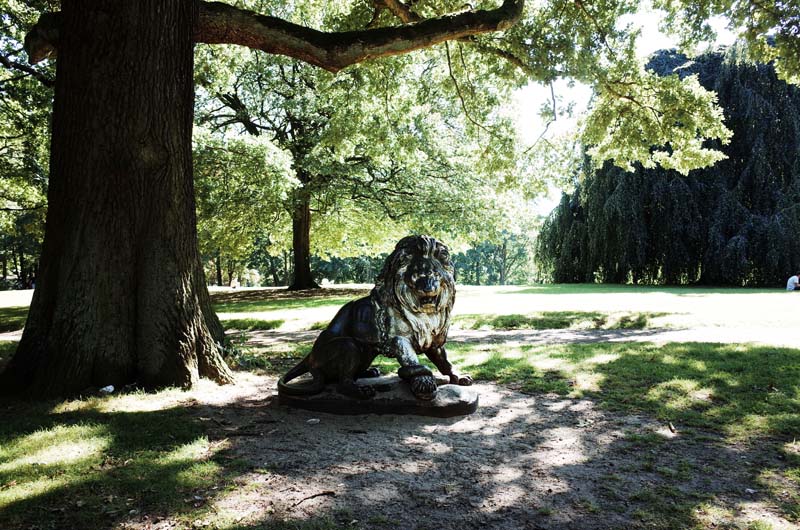
Fig. 1. The elusive lion statue in Blohms Park, Hamburg.
My lion friend is yet another example of the material dissimulation of the history I have been exploring in this fellowship project. Unlike the obdurate presentation of history I encountered during my travels to Tyntesfield in Bristol and Port Sunlight in Liverpool however, the anonymous statue in Blohms Park makes no claims to its historical significance, nor does it account in any way for its provenance. It is simply there: a hollow-eyed, somewhat graffitied and agitated figure, crushing an unknown species of serpent with its violent claws. Nevertheless, I know this lion well, having seen it many times in photographs of a building that no longer exists, but which once towered over the inner Hamburg suburb of Hamm (figure 2). The Villa Ohlendorff was a neo-Renaissance Stadtpalais (city palace) built between 1872 and 1874 to the design of the architect Martin Haller. Its owner, Heinrich von Ohlendorff, was the largest importer of Peruvian guano in nineteenth-century Germany, entering the trade in the 1860s shortly after the period of the Antony Gibbs & Sons monopoly discussed in my previous report. The villa was spread across two vast levels, containing 18 rooms on the parterre and a further 14 on the first floor. Marble stairs, columns, walls and bathrooms were offset by an oak-paneled dining room and a gold-leafed ceiling in the ballroom (figure 3). A windowless octagonal chamber adjoined the salon, dedicated to playing the card game skat without distraction by the blustery northern weather. The house was set in six hectares of parkland containing exotic trees, a waterfall, fountain, grotto and a greenhouse for Ohlendorff’s extensive orchid collection (figure 4).1 Two large staircases flanked the building’s entry, conveying visitors to the opulent interior, adorned at either end by a cast-iron statue of a lion. Following the destruction of the Villa Ohlendorff during the allied bombing of 1943, the Blohms Park lion is all that remains of Heinrich von Ohlendorff’s once sprawling guano palace.
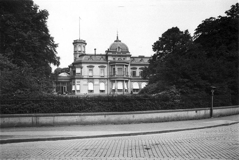
Fig. 2. The Villa Ohlendorff, c.1920. Source: Commons.
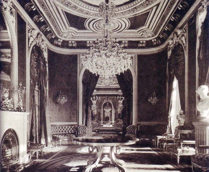
Fig. 3. Interior of the Villa Ohlendorff c.1875. Source: Commons.
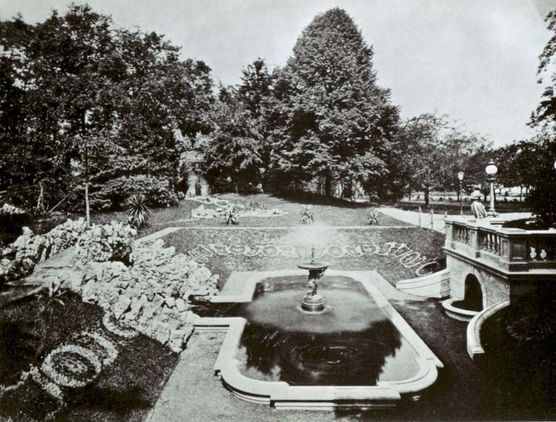
Fig. 4. The fountain and waterfall in the grounds of the Villa Ohlendorff, c.1875. Source: Commons.
As in Bristol and in Liverpool, so in Hamburg: Ohlendorff’s ostentatious home again obfuscated the conditions under which the capital invested in it had been acquired. Just as the Peruvian guano trade during the Gibbs monopoly period relied upon an elaborate and coercive labor regime to realize the latent value of the Chincha Islands within the emerging markets of industrial capitalism, so too did Ohlendorff & Co. profit from the “superexploitative character” of indentured Chinese labor in Peru (figures 5 and 6).2 The extracted material, once processed and sold as fertilizer, contributed to a dramatic increase in agricultural productivity: between 1870 and 1910, the value of annual harvests doubled in Germany as rates of chemical fertilization increased by over one thousand percent in line with Liebig’s entrenched model of “rational agriculture.” In supplying the fuel for this growth, Ohlendorff & Co. eventually established industrial facilities in Hamburg, London, Antwerp and Emmerich am Rhein, processing up to 140 shiploads of Peruvian guano annually.3 The company developed a major presence in the European fertilizer industry more broadly as a result, competing with the likes of Lawes Chemical Manure Company and delivering a personal fortune to Heinrich and his brother Albertus. In 1883, Ohlendorff & Co. was reconstituted as the Anglo-Continental Guano Works, transitioning to chemical fertilizer production—especially superphosphate—throughout Europe and England prior to the seizure of its assets outside of Germany following World War One.
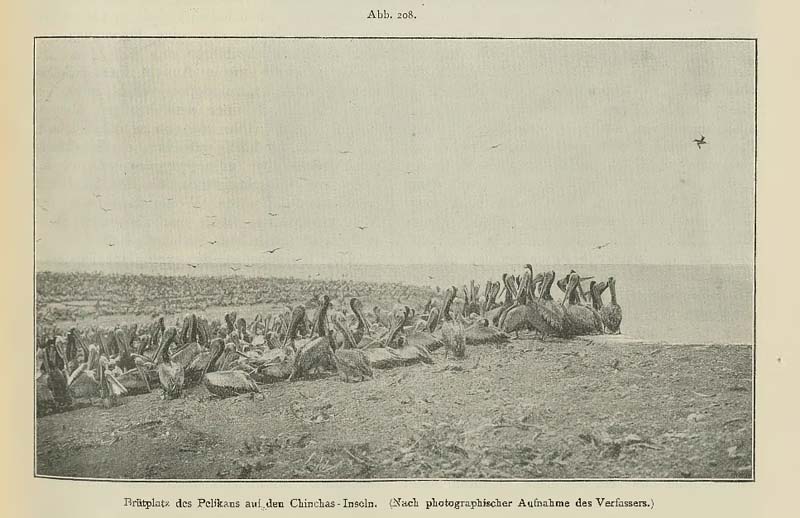
Fig. 5. “Pelican breeding grounds on the Chincha Islands.” Source: Walter von Ohlendorff, “Die Guanolager in Peru und Chile,” Prometheus: Illustrierte Wochenschrift über die Fortschritte in Gewerbe, Industrie und Wirtschafft, no. 436 (1898), 311.
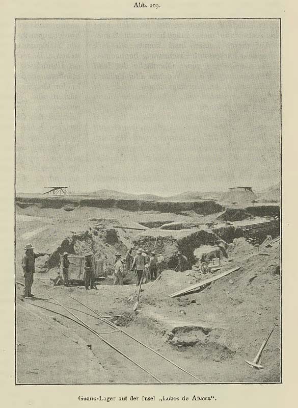
Fig. 6. “Guano deposits on ‘Lobos de Afuera’.” Source: Walter von Ohlendorff, “Die Guanolager in Peru und Chile,” Prometheus: Illustrierte Wochenschrift über die Fortschritte in Gewerbe, Industrie und Wirtschafft, no. 436 (1898), 313.
The original objective of this fellowship project was to understand the role of synthetic fertilizers in enacting a kind of triple displacement in the Australian colonies, whereby the biogeochemical transformation of Indigenous Country into the landscapes of colonial agriculture was enabled by the coercive expropriation of resources and labor throughout the Indo-Pacific, which in turn ensnared certain Indigenous populations and ecologies within the expanding geography of Australia’s settler colonial project. The term chemification, proffered by the sociologist Marion W. Dixon, has proven useful as a heuristic in organizing this thinking. According to Dixon, chemification encompasses “the processes by which imperial states gained territories (and land, labor, etc.) through industrial power built on assemblages of production, energy, and materials connected via a handful of chemicals.”4 However, in my travels to date, I have already found it necessary to extend my consideration of these processes to encompass the various continuities between the proto-industrial guano industry of the nineteenth century, developed by the likes of Ohlendorff & Co. and Antony Gibbs & Sons, and the heavily industrialized superphosphate industry of the twentieth century in which manufacturers such as Cuming Smith & Co. and Lawes Chemical Manure Company were active internationally. Drawing on Jason W. Moore’s work on “historical nature,” my last report argued that this shift from guano to rock phosphate involved scientific, imperialistic, and capitalistic innovations that expanded the possibilities for primitive accumulation by further cheapening nature and labor alike.5 Australian settler colonialism, given its disproportionate reliance on synthetic fertilizers, was thus an agent in the instantiation of the structures of global capitalism elsewhere.
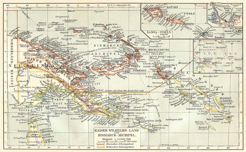
Fig. 7. Map of the German New Guinea Schutzgebiet, which included both Nauru and Angaur following the incorporation of the German Marshall Islands in 1906. Source: Kaiser-Wilhelms-Land, Deutsch-Neuguinea, Landkarte, c.1906, Bibliographisches Institut, Leipzig.
At the risk of straying still further from my original objective, I have spent the last month or so traveling around northern Germany. Germany is significant to this project because Nauru and Angaur—two Micronesian islands of great importance for the Australian superphosphate industry—were located in German colonial territory before World War One (figure 7). As I have traveled from place to place, my thinking has focused on the different kinds of political order that proponents of the chemical fertilizer industry were required to navigate and the types of spatial production these orders both presupposed and enabled in turn. I have found it helpful to conceptualize this relation as a question of form: how did the administrative form of German colonial governance over Nauru and Angaur—in particular, the legal instrument of the protectorate or Schutzgebiet—influence the spatial-technical form—buildings, machinery, equipment, infrastructure—deployed to exploit the rock phosphate deposits on both islands? Did this relation also work in the other direction i.e., infrastructural development informing the structures of colonial governance? What is the political relationship between Ohlendorff’s guano imperialism in Peru and the colonial phosphate industries established in German Micronesia? To what extent is this relationship still legible in the urban fabric of Germany today? And how does the history of the superphosphate industry figure within the broader history of Germany’s ascent as a global colonial power?
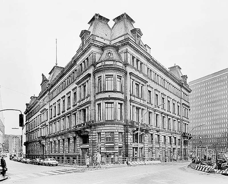
Fig. 8. The Dovenhof. Source: Commons.
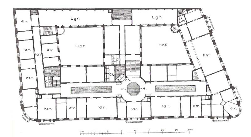
Fig. 9. Ground floor plan of the Dovenhof, designed by Martin Haller for Heinrich von Ohlendorff in 1886. Source: Commons.
The story of Heinrich von Ohlendorff’s rise to wealth and prominence in Hamburg on the back of his company’s guano exploits in Peru presents a useful analogue of the corporate structure of German imperialism and its evolution towards outright colonialism in 1884. It is also a story in which the architect Martin Haller reappears as the designer of choice, not only for Ohlendorff’s private and commercial ventures, but for the colonial metropole of Hamburg more broadly. In 1886, three years after the formation of the Anglo-Continental Guano Works, Haller was again commissioned by Ohlendorff, this time to design the Dovenhof—the first Kontorhaus (office building) in the city. The Dovenhof represented a diversification in Ohlendorff’s business interests, the wealth extracted from Peru now being reinvested into an incipient real estate empire in Hamburg at a moment when the global fertilizer industry was transitioning away from guano towards more potent synthetic alternatives. The four-story building presented a neo-Renaissance façade to the street, curving at its corner and rising from street level to an unusual domed turret embedded into the main volume of the building between tall pilasters (figure 8). Mirrored glass windows and its scale in comparison with the surrounding urban form immediately signaled the modernity of the Dovenhof notwithstanding the conservative treatment of its façade.6 A tall octagonal vestibule—perhaps a nod to the octagonal skat room in the Villa Ohlendorff—connected the main circulation routes through the building, which incorporated the first steam-powered paternoster lift in continental Europe. Central heating and electric lighting maintained regular conditions inside the partitioned offices (Kontore), which opened onto corridors illuminated during the day by lightwells (figure 9). Two large courtyards punctuated the overall volume, bringing yet more light into the offices while also separating them from the storage rooms running along the back of the building.7
Fig. 10. The Dovenhof was demolished in 1967 to make way for the former headquarters of the newspaper Der Spiegel.
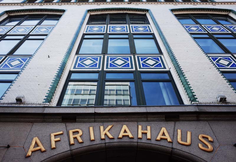
Fig. 11. The glazed masonry façade of the Martin Haller-designed Afrikahaus.
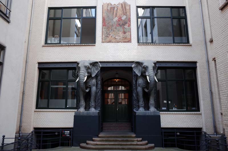
Fig. 12. Two life-size elephants occupy the courtyard of the Afrikahaus and are visible from the street.
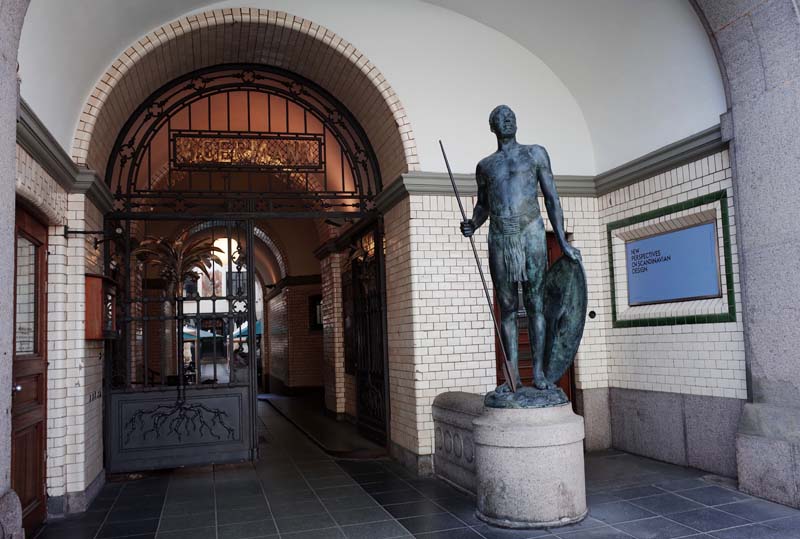
Fig. 13. The entry portal to the Afrikahaus includes a sculpture of a Hehe warrior by Walter Sintenis.
The Dovenhof was a prudent exercise in speculation, located directly adjacent to the Zollkanal (customs duty canal), which marked the outer perimeter of the Hamburg free port and the emerging Speicherstadt (lit. “warehouse city”). The building’s tenants—importers, underwriters, lawyers and creditors—were therefore in the closest possible proximity to the Speicher (warehouses) through which overseas trade flowed into Hamburg. Other Kontorhäuser soon followed the example set by Ohlendorff’s Dovenhof, which was demolished in 1967 to make way for the offices of Der Spiegel (figure 10). Two prominent examples remain intact and are important points on the self-guided colonial walking tour developed by a network of organizations involved in the Hamburg Postcolonial initiative.8 The Afrikahaus, commissioned in 1899 by Adolph and Eduard Woermann for their company C. Woermann, was again designed by Martin Haller (figure 11). C. Woermann operated shipping services between and throughout German colonial holdings in Africa, boasting several company offices at key ports along the west coast. The Kontorhaus in Hamburg served as its global headquarters. Haller’s design for the self-supporting glazed masonry façade of the Afrikahaus incorporates the livery of the company’s fleet, as well as a variety of “African” ornaments including two life-size elephants and the figure of a Hehe warrior completed by the sculptor Walter Sintenis (figures 12 and 13). Offices are arranged around a narrow courtyard and are served by many of the same modern contrivances first incorporated in the Dovenhof.
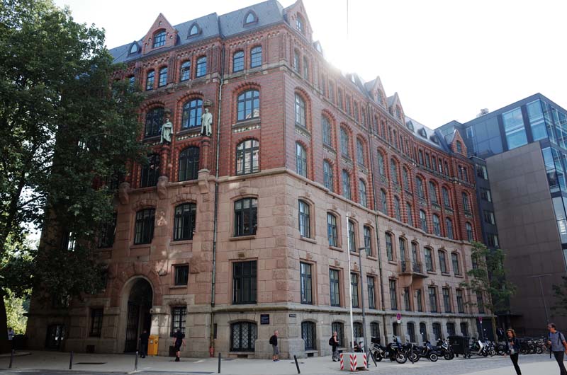
Fig. 14. The Laeiszhof abuts the Nikolaifleet canal to the rear and addresses a small plaza formed around its main entry.
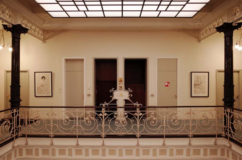
Fig. 15. The lightwell and paternoster lift of the Laeiszhof
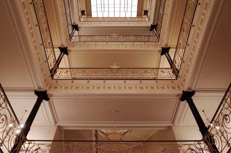
Fig. 16. The central void in the Laeiszhof closely resembles Haller’s design for the Dovenhof, the original Kontorhaus in Hamburg.
Nearby, Haller also designed the Laeiszhof in 1897—headquarters of the still extant shipping company F. Laeisz—together with Bernhard Georg Hanssen and Wilhelm Emil Meerwein (figure 14). Laeisz was heavily involved in the Chilean nitrate trade until the 1920s when the Haber-Bosch process eliminated the need to mine saltpeter for use as a fertilizer. The company was also involved in shipping in general, especially the importation of bananas and other fruit from Africa. To house its diverse activities, Haller returned to the Dovenhof as a precedent, again incorporating a large lightwell in the center of the building, which extends to the boundaries of its site abutting the Nikolaifleet canal. An operational paternoster lift still fills the interior with a drumming and whirring sound, propelling businesspeople between the building’s six floors (figure 15). White-painted walls and wrought iron balustrades bounce the filtered daylight around the central void of the building, combining with the electric lighting to produce a calm warm glow (figure 16).
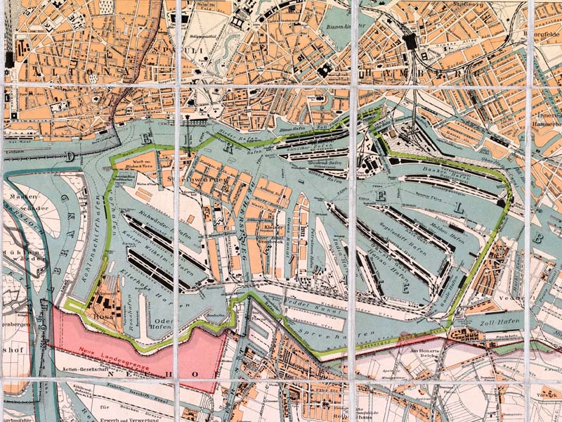
Fig. 17. The limits of the Hamburg freeport are shown in green. Source: Richard Krause, Plan der Elbinseln Wilhelmsburg, Neuhof u. Hohe Schaar sowie Moorburg, Altenwärder u. Waltershof, 1900.
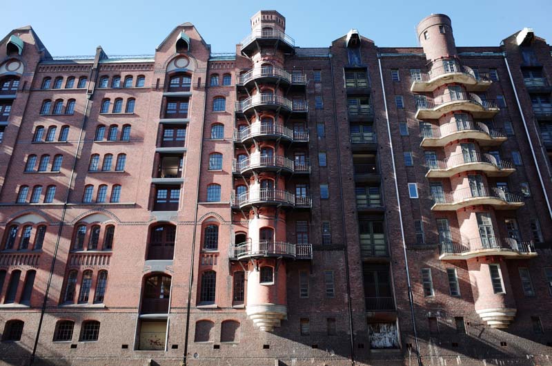
Fig. 18. Warehouses in Hamburg’s Speicherstadt.
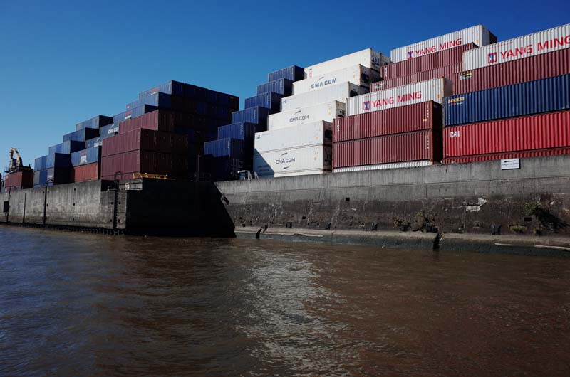
Fig. 19. Shipping containers occupy the former site of Ohlendorff’s Anglo-Continental Guano Works.
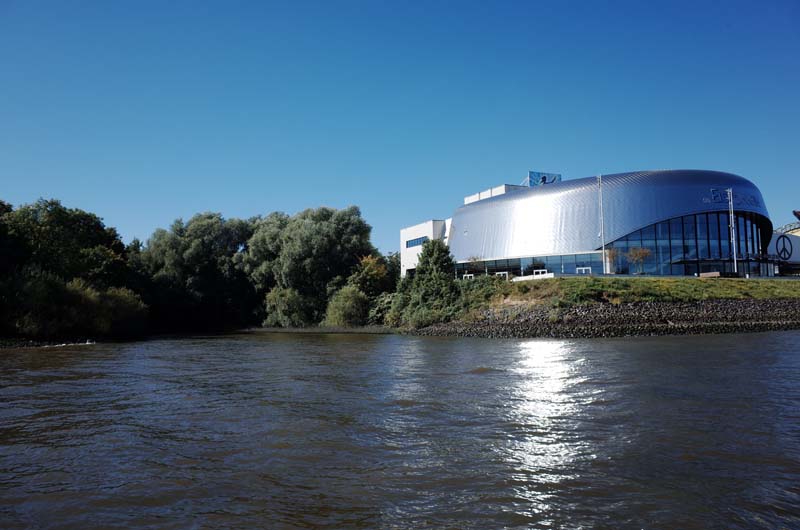
Fig. 20. The Guanofleet, which once served Ohlendorff’s Anglo-Continental Guano Works, can be seen in the overgrown creek mouth to the left. The silver dome is a theatre dedicated to recitals of Disney’s The Lion King musical.
Like the Haller-designed Dovenhof, Afrikahaus and Laeiszhof, all of Hamburg’s Kontorhäuser were located near the Speicherstadt, which grew to become the world’s largest warehouse complex before World War One as a result of its status as a duty-free port (figure 17).9 Imported raw materials and goods—bananas, coffee, cacao, cotton, copra—were unloaded from seagoing vessels onto barges that navigated the free economic zone’s network of canals before being raised up to nine stories into the large, mechanized Speicher lining the canals (figure 18). All goods were received, stored and processed in the Speicher without attracting any duties until they entered the city as so-called Kolonialwaren (colonial wares). Crucially, as visible in figure 17, the duty-free zone not only encompassed the Speicherstadt, but also the industrial facilities developed on numerous islands on the opposite side of the Elbe: Wilhelmsburg, Steinwerder, Veddel and Kleiner Grasbrook. The Guanofleet, a narrow canal in Hamburg-Steinwerder, still recalls the once sprawling industrial footprint of Ohlendorff’s Anglo-Continental Guano Works, now replaced by a sea of shipping containers (figure 19). “India Harbor,” “Asia Quay” and “Africa Spit” were also once found throughout the Hamburg free port in areas now used to store second-hand cars bound for Africa, as well as a theatre dedicated to recitals of Disney’s The Lion King musical (figure 20).
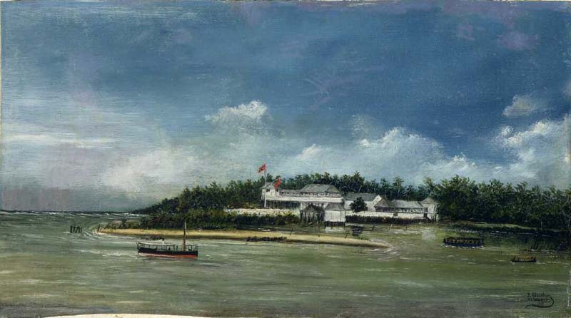
Fig. 21. The Godeffroy & Sohn trading post in Apia, Samoa. Source: J. Ullstrom, The Pacific Trading Post, Alexander Turnbull Library, Wellington, 23078019.
Fig. 22. The “Hamburg Street” in Lomé, Togo, c.1909. Source: Kurt Schwab and Fr. Böhme, Die deutschen Kolonien (Berlin: Publisher Unknown, 1910).
The Hamburg free port, which both enabled Ohlendorff’s multifaceted commercial enterprise and undergirded Haller’s career as an architect, was a spatio-political outcome of Hanseatic imperialism. This history long preceded the country’s unification under Chancellor Otto von Bismarck in 1871, let alone its entry into formal colonialism in the 1880s. By 1846, Hanseatic firms already maintained close to 160 trading posts and so-called “Konsulanten” (consulates) globally, rising to 280 over the next two decades.10 The Hamburg merchant Johann Cesar Godeffroy, operating out of Samoa from the mid-1850s, developed a vast network of trading stations spanning Tonga, Wallis and Futuna Islands, Niue, the British Gilbert and Ellice groups, the Spanish Carolines and the Marshall Islands (figure 21).11 Godeffroy & Sohn eventually purchased coconut and cotton plantations worked by more than 1200 laborers and frequented by a company fleet of around one hundred ships, the majority of which had been built in Hamburg.12 In 1878, Godeffroy & Sohn was reconstituted as the Deutsche Handels- und Plantagengesellschaft der Südsee-Inseln zu Hamburg (German Trading and Plantation Company of the South Sea Islands), which would go on to play a decisive role in the commencement of phosphate mining on Nauru. By 1880, companies headquartered in Bremen and Hamburg had established approximately twenty trading stations on the west coast of Africa alone, acquiring goods, wares and resources that were regularly conveyed back to Europe by C. Woermann, F. Laeisz and others (figure 22). The establishment of the Hamburg free port, which followed the city’s accession into the German Customs Union in 1888, thus maintained the position of trade within the economic and political life of the city during the period of German colonialism.
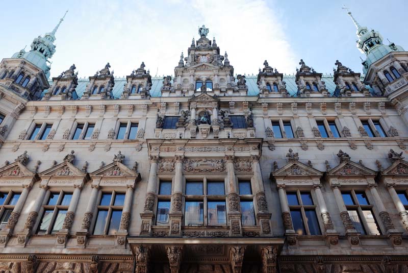
Fig. 23. The Hamburg town hall, designed by Martin Haller.
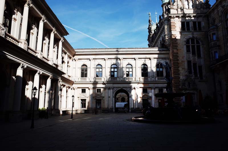
Fig. 24. The Ehrenhof connects the Hamburg town hall and the stock exchange
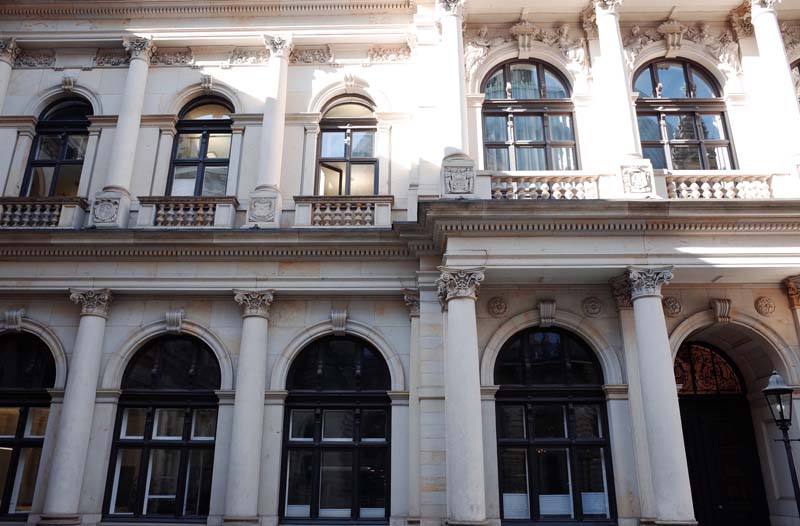
Fig. 25. City crests affixed to the base of the second row of columns in this image run around the façades facing into the Ehrenhof, representing the historical geography of Hamburg merchants’ involvement in global trade. Allegorical figures representing each continent are seen above.
Heiko Möhle has observed that, in Hamburg, “the path between politics and the economy has always been a short one.”13 What in fact separates the two, however, is less a path than an enclosed square of approximately twenty meters in length—the so-called Ehrenhof—that spans the distance between Hamburg’s town hall (1897) and the city’s stock exchange building (1840), home to the Hamburger Handelskammer (Chamber of Commerce). The financial-administrative complex spatializes what Möhle describes as “a close relationship with a long history.” As the representative body of Hamburg’s merchant elite, “the Handelskammer defined the city’s economic interests, while the Senate worked to implement those interests politically.”14 Unsurprisingly, the design for the town hall in which the Senate resided was prepared (yet again) by the architect Martin Haller, whose career is emblematic of the commercial opportunities arising in the metropole as a result of German imperialism (figure 23). Haller’s design for the town hall formalized the interstitial space between it and the stock exchange—thereby creating the Ehrenhof—through the addition of two portals flanking a central square and fountain (figure 24). City crests and allegorical relief art run along all four facades facing into the square, representing the historical geography of Hamburg merchants’ involvement in global trade. The crests are arranged around the courtyard in a loosely geographical manner, starting with the Americas—New York, San Francisco, Rio de Janeiro and Valparaiso—then moving to the Asia-Pacific—Hong Kong, Melbourne, Sydney, Batavia, Singapore, Manila and Yokohama—before arriving at ports throughout Europe and the United Kingdom (figure 25). A series of strange figures intending to portray each continent is incorporated atop the city crests along the back façade of the stock exchange building—including, for example, an Australian Aboriginal woman adorned with a bow and arrow. In establishing the Ehrenhof as a kind of fulcrum between the Senate and Handelskammer, stitching them into a continuous architectural and urban fabric, Haller’s design worked to naturalize the imbrication of Hamburg’s foundational imperial institutions—the latter, an embodiment of the imperial, pre-colonial interests of the city’s merchants; the former, a vehicle for consolidating those interests during the period of high colonialism.15
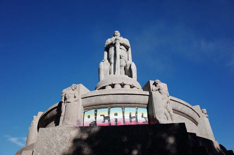
Fig. 26. Hamburg’s Bismarck statue overlooks the city and faces towards the mouth of the Elbe in the North Sea.
Engaging with Hamburg’s urban history reveals the extent to which German colonialism can be understood as a political concession to the commercial interests (and indefatigable lobbying) of Hanseatic traders. In 1883, Adolph Woermann authored a memorandum sent to Bismarck on behalf of the Hamburger Handelskammer seeking enforceable protections for Hanseatic trading interests in Africa. “The interior of Central Africa,” argued Woermann, “with its dense population capable of high levels of consumption and the vast trade potential described by all travelers, offers a particularly favorable region for distributing European industrial products, especially since not only all commodities, but also all labor is paid for not with cash […] but always with imported goods.”16 The eventual colonial intervention of the German state in Africa came a year later in response to the sustained requests of the Bremen trader F. A. E. Lüderitz who likewise sought protection from the Reich over his business interests north of the Cape Colony. His request was finally granted by Bismarck in June of 1884, leading to the establishment of German South West Africa as the empire’s first Schutzgebiet. Bismarck’s oft-cited refrain, “Die Flagge folgt dem Handel” (the flag follows trade) placed German merchants’ interests at the center of formal colonialism, a fact commemorated in Hamburg with the erection in 1906 of an imposing statue of the former chancellor overlooking the city and facing towards the mouth of the Elbe in the North Sea (figure 26).17 Other Schutzgebiete soon followed: in Africa—Kamerun (1884), Togoland (1884) and German East Africa (1885); the Pacific—Kaiser-Wilhelmsland (1884), Bismarck-Archipel (1884), Marshall-Inseln (1885), Salomon-Inseln (1885), Nauru (1888), Die Karolinen (1899), Die Marianen (1899) and Deutsch-Samoa (1900); and China with the annexation of Kiautschou in 1898.18 As the legal scholar Cait Storr has argued, the expansion of the German state into these regions under Bismarck and his successors, and the “political balance between private equity and state subsidy” is best understood not as a “rapid expansion of ‘the German empire’ in the late nineteenth century but as an episode in a far longer history of the shift from one form of European imperialism towards another—from the non centralised merchant trade network run from the Hanseatic cities, towards the centralised state imperialism of the new Reich.”19
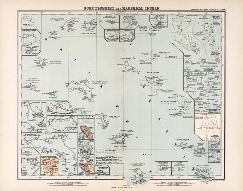
Fig. 27. The German Marshall Islands Schutzgebiet. Source: Paul Langhans, Schutzgebiet der Marshall-Inseln, Deutscher Kolonialatlas, Map 30, 1897.
The longer history Storr addresses not only shaped the urban development of Hamburg as a site where the spoils of German imperialism—including the guano imported by Ohlendorff—were processed in the most frictionless way possible, but also shaped the later administrative form of German colonialism via the legal instrument of the Schutzgebiet. “Whereas classical conceptualisations of protectorate status arose from an agreement between unequal sovereigns for ‘protection’ of the weaker party,” continues Storr, “in the late nineteenth century the label was increasingly used to describe a variety of imperial arrangements in which concepts of sovereignty, territory and property remained ambivalent, if not incoherent.” This ambivalence, Storr argues, enabled the German state to conduct a “unique imperial experiment” in which its consular jurisdiction was territorialized in the Schutzgebiete as minimally as possible, “with delegated executive control vesting in German companies themselves, with minimal subsidization and little to no legislative oversight.”20 The Schutzgebiet, in other words, was the fundamental legal-territorial condition of German colonialism, becoming the de facto manner in which German colonies were established into the twentieth century including on Nauru and Angaur. It incentivized the extraction and circulation of commodities and labor by German corporations as a basis for raising tax revenue rather than incentivizing migration and permanent settlement. This is one reason why many Germans still equivocate when it comes to the country’s colonial patrimony: “Yes, we had colonies but not real colonies like the British” is a refrain I encountered numerous times over the course of my travels. Insofar as this is an accurate assessment it is one that rests on a spurious distinction between the administrative forms of colonial sovereignty, reducing the plurality of modern colonialism to settler-colonialism only.
The geographer Joshua Barkan has argued for more nuanced understandings of what he terms “corporate sovereignty,” or the ways in which political sovereignty has been vested in private power—via, for example, the legal technology of the protectorate—and the subsequent importance of the corporation as an institutional form within liberal capitalism.21 The late-nineteenth-century German Pacific, owing to its deep political, economic and material entanglements with the evolving colonial metropole of Hamburg, arguably presents Barkan’s case in point: in 1884, the Deutsch Neuguinea-Kompagnie was formed as a chartered company to exploit resources and administer the territory of German New Guinea on behalf of the Reich; in 1888, the Jaluit-Gesellschaft was created to perform the same functions throughout the Marshall Islands Protectorate via a merger in Hamburg between Hernsheim & Kompagnie and the DHPG, which was itself formed out of Godeffroy & Sohn a decade earlier as already mentioned; and in 1902, the Jaluit-Gesellschaft was reconstituted as the Pacific Phosphate Company through a joint-stock agreement with the Pacific Islands Company in order to work the phosphate deposits on Nauru and administer the island.
German firms received various exclusive rights and the promise of military protection in these agreements. According to the historian Stewart Firth, in the administration of its Pacific Schutzgebiete, the German Imperial Government effectively functioned as an agent of “private companies, providing legality for whatever the companies wished to do,” and supplying them with “cheap land, long mining leases, low royalties and a disciplined, underpaid labour force” subject to minimal regulation.22 In the German Marshall Islands, the Jaluit-Gesellschaft was given “the right to take possession of ownerless land, the right to engage in fishing for pearlshell […and] the right to mine guano deposits,” in return for which it was expected to “meet the costs arising from the administration [of the Schutzgebiet]” and to collect license fees and “head-taxes.”23 In German New Guinea, the same administrative logic could be discerned in the discrepancy between the paltry European population figures up to World War One and the fact that the territories encompassed by the Schutzgebiet were heavily developed by this time—containing 10,000 hectares of plantations, roads, industrial mining infrastructure, a functional taxation system and a ten-year plan for future works prepared by Governor Albert Hahl.24 As stated by Secretary of State for the Colonies Bernhard Dernburg in his Zielpunkte des deutschen Kolonialwesens (1907), German colonialism should focus on precisely this kind of productive infrastructural development, substituting the “means of destruction (Zerstörungsmittlen)” he associated with settler-colonialism—referring in a veiled way to the genocidal war perpetrated by the Reich on behalf of settlers in German South West Africa between 1904 and 1907—for German medical, missionary and engineering expertise aimed at the “utilization (Nutzbarmachung) of the earth, its treasures […] and especially the people.”25 Efficient and reliable extraction and accumulation, not settlement and local state formation, argued Dernburg, were the primary goals of early-twentieth-century German colonialism.

Fig. 28. German government building in Tsingtao in F. H. Schmidt catalogue. Source: “F. H. Schmidt, Bauunternehmung, Altona, Hamburg, Tsingtau,” Historisch-biographische Blätter: der Staat Hamburg 7 (1905/6), Staats- und Universitätsbibliothek Hamburg.
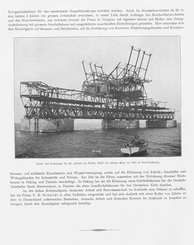
Fig. 29. F. H. Schmidt loading and unloading facilities fabricated for the la Société Le Nickel, Paris in New Caledonia. Source: “F. H. Schmidt, Bauunternehmung, Altona, Hamburg, Tsingtau,” Historisch-biographische Blätter: der Staat Hamburg 7 (1905/6), Staats- und Universitätsbibliothek Hamburg.
The Schutzgebiet therefore presupposed and facilitated an infrastructuralism that was implemented on behalf of the state by private, usually Hanseatic companies. As Storr argues in relation to Nauru in the German Marshall Islands, the governmental history of that Schutzgebiet is one in which legal status shifted while administrative form accreted: “A simple administrative outline, originally sketched in 1888 by a Hanseatic trading company in a deal with the Bismarckian Reich, was progressively bureaucratised over time. Administrative tasks and practices intensified, were restated and renamed; but the form in which they were organised held firm.”26 Importantly, as Dernburg’s overt infrastructuralism already reveals, this gradual administrative intensification and bureaucratization—what Storr labels “accretion”—was also an enterprise premised on German technical expertise. Here, Nauru remains an instructive example: as soon as the Pacific Phosphate Company had been established to work the Nauruan rock phosphate deposits through a complicated agreement spanning Hamburg, Berlin and London, the Hamburg-Altona construction and engineering firm F. H. Schmidt was contracted to supply industrial equipment and facilities for a company settlement on the island, seemingly as a condition of the administrative terms established by the Reich. F. H. Schmidt had built houses, harbors, bridges and maritime infrastructure around Hamburg since the 1840s, portraying its engineering and logistical achievements as part of a wider narrative of German colonial ascendancy: “Since Germany has acquired its own colonies,” a promotional pamphlet from 1906 observed, “the company has substantially developed its activities in turn.”27 In German East Africa, F. H. Schmidt provided prefabricated government dwellings. In the German concession of Qingdao in China, it employed a large local labor force, designing and constructing the barracks, government buildings, brewery, hospitals, factories, offices and villas, as well as much of the civic and maritime infrastructure (figures 28 and 29). Reflecting on these and the many other projects it had completed by the time it was awarded the contract for Nauru, F. H. Schmidt was happy that it had, “for a number of years already, successfully elevated the reputation of German companies, German work and German ability through its building operations.”28 The continuities at play here are revealing: the acquisition of German colonial territory using the legal instrument of the Schutzgebiet—initially deemed most suitable in protecting existing Hanseatic trading interests—also secured new spheres of commercial activity for the same German technical expertise that had been cultivated in the Hanseatic centers since the pre-colonial period.
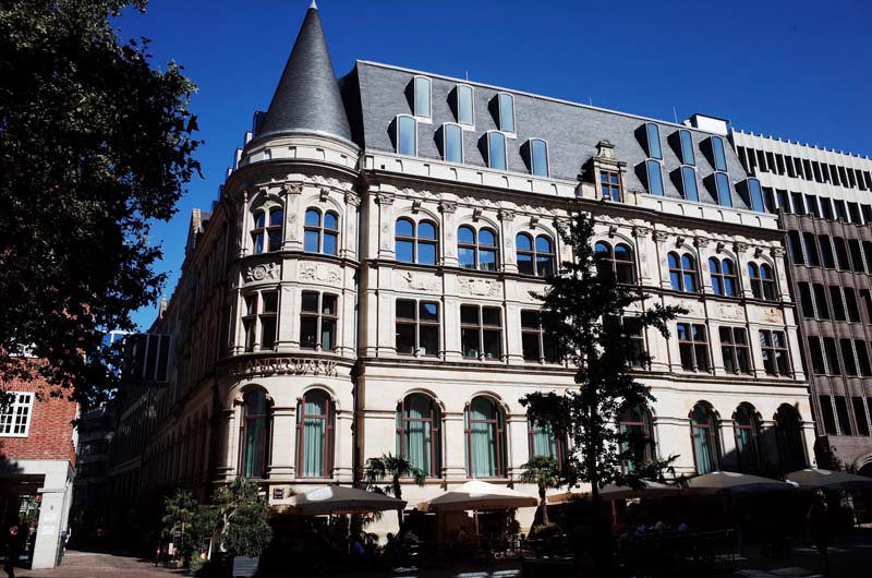
Fig. 30. The former Deutsche Nationalbank zu Bremen, meeting place for the Deutsche Südseephosphat Aktiengesellschaft.
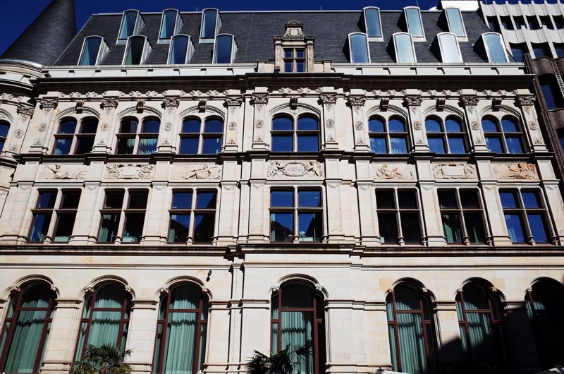
Fig. 31. The former Deutsche Nationalbank zu Bremen, meeting place for the Deutsche Südseephosphat Aktiengesellschaft.
To better understand how the superphosphate industry figured among the blurred edges of German imperialism, colonialism and infrastructuralism, I traveled west from Hamburg to the neighboring Hanseatic city of Bremen. I find my first destination in the historic center, behind the city’s fifteenth-century town hall. The former headquarters of the Deutsche Nationalbank zu Bremen was erected in 1896—a year before Haller’s town hall was completed in Hamburg—to the design of the Deutsche Nationalbank’s in-house architect, Wilhelm Martens (figures 30 and 31). It was in this building’s stately interior that the board members of the Deutsche Südseephosphat Aktiengesellschaft (German South Sea Phosphate Company Limited, DSPAG), which was granted an exclusive phosphate mining concession for Angaur in German New Guinea, would come together for the company’s annual general meetings. The first of these was held in 1908 and the founding board members in attendance read as something of a who’s who of Germany’s financial-industrial-chemical complex: two seats were occupied by the Norddeutscher Lloyd (North German Lloyd) shipping company, which serviced the Reich’s Pacific territories and Australia; two were held by the Frankfurt-based mining and chemicals company Beer, Sondheimer & Co; the Deutsche Nationalbank zu Bremen held one position on the board and administered the company’s investment capital; one seat each was held by the Deutsche Bank in Berlin and H. & E. Albert of Wiesbaden-Biebrich, a superphosphate fertilizer producer formed in the immediate wake of Liebig’s discoveries in the 1850s, as well as the Rotterdam-based mining and shipping company H. Mueller & Co.
The DSPAG was established after Albert Hahl, Governor of German New Guinea, met with the general manager of the Norddeutscher Lloyd, Heinrich Wiegand, in Bremen to outline the commercial viability of the Angaur deposits. Hahl believed the Lloyd was especially well placed to work the island given its established shipping activities in the region. Wiegand agreed, reporting in 1906: “The great importance of the further economic development of the South Seas protectorate for our steamship lines prompted us last year to send an expedition to explore the mineral resources of the island region in conjunction with a number of associated companies.”29 The results of this expedition were favorable and revealed that the majority of Angaur was covered in valuable high-grade rock phosphate. Wiegand quickly got to work in assembling the cast of board members listed above, while Governor Hahl made the case for granting a mining lease on behalf of the Lloyd to Dernburg as Secretary for the Colonies—this being one of the very first issues to which Dernburg attended in his newly appointed role.
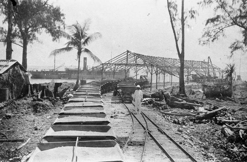
Fig. 32. Preliminary tracks, carts and loading equipment on Angaur, provided to the Deutsche Südseephosphat Aktiengesellschaft by F. H. Schmidt. A Lloyd steamer waits to be loaded in the background, c.1908. Source: Deutsches Bundesarchiv, Sammlung Heinrich Hagedorn, Bild 223-046.
My travels will take me to Angaur in the coming months and I will return to the infrastructural presence the DSPAG established there in greater detail in a future report. Here, I wish only to make two observations. The first is that, like Martin Haller in Hamburg, the construction company F. H. Schmidt reappeared throughout German colonial territories at the turn of the twentieth century, especially where governmental and industrial functions were combined as was the case on Nauru and Angaur. In the autumn of 1908, Lloyd company ships left Bremen for Angaur carrying the first shipment of DSPAG housing and mining equipment, which had been designed and constructed by F. H. Schmidt and included a full arsenal of locomotives, wagons, rails and sleepers, storing and loading equipment, prefabricated timber buildings, water treatment facilities, as well as the devices required to establish a radio connection with the island of Yap in the Caroline Islands (figure 32). F. H. Schmidt therefore provided the company settlements and industrial facilities for both rock phosphate islands in German Schutzgebiete in the Pacific, further expanding its own commercial geography in the process.
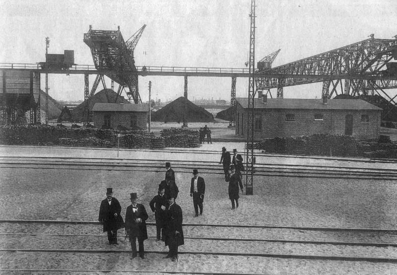
Fig. 33. Facilities at the Norddeutsche Hütten AG, c.1908. Source: Commons.
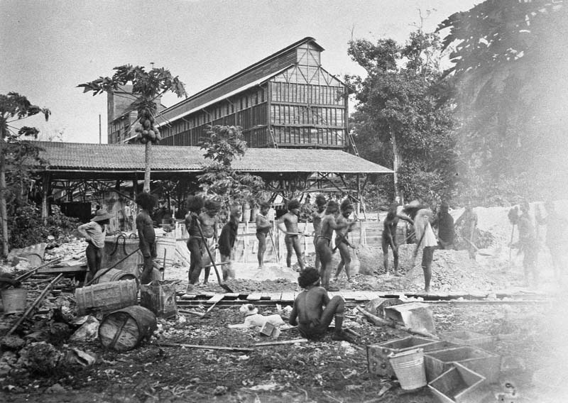
Fig. 34. The so-called Hoffnungshütte fabricated by F. H. Schmidt for the Deutsche Südseephosphat Aktiengesellschaft on Angaur, c.1912. Source: Deutsches Bundesarchiv, Sammlung Heinrich Hagedorn, Bild 223-038.
The second observation is that the DSPAG’s mining activities on Angaur are best understood in light of the broader expansionist project undertaken by the Norddeutscher Lloyd during Wiegand’s tenure as general manager. In the first decade of the twentieth century, Wiegand sought to transform the Lloyd into a vertically integrated industrial corporation, establishing the so-called “Wiegand industries” and becoming a major driver of industrialization along the Weser River. In addition to mining and exporting rock phosphate in German New Guinea, these industries included the Norddeutsche Maschinen- und Armaturfabrik (North German Machine and Instrument Factory), established in 1902, which supplied the Lloyd’s ships and other maritime equipment; the Norddeutsche Automobil- und Motorenwerke AG (North German Automobile and Motor Company Limited), established in 1906; the Norddeutsche Hütten AG (North German Metallurgical Company Limited) and the Norddeutsche Waggonfabrik (North German Wagon Factory), both established in 1908, the latter of which manufactured the trains that transported the coal and ore to the coking plant and smelters of the former, before being loaded again with pig iron conveyed to the Ruhr for steel manufacturing (figure 33). It is likely that the integrated phosphate crushing, drying and loading facility prefabricated by F. H. Schmidt for use on Angaur, named the Hoffnungshütte (lit. “hope hut), was understood as a Pacific outpost of the Wiegand industries (figure 34).
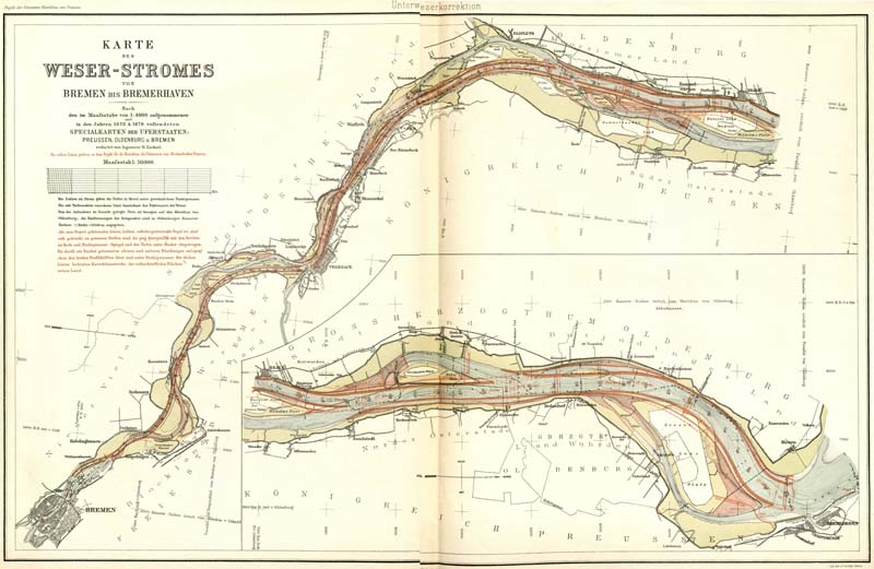
Fig. 35. The regularization of the Weser River is indicated in red in this plan. Source: Ludwig Franzius, Karte des Weser-Stroms von Bremen bis Bremerhaven, 1888.
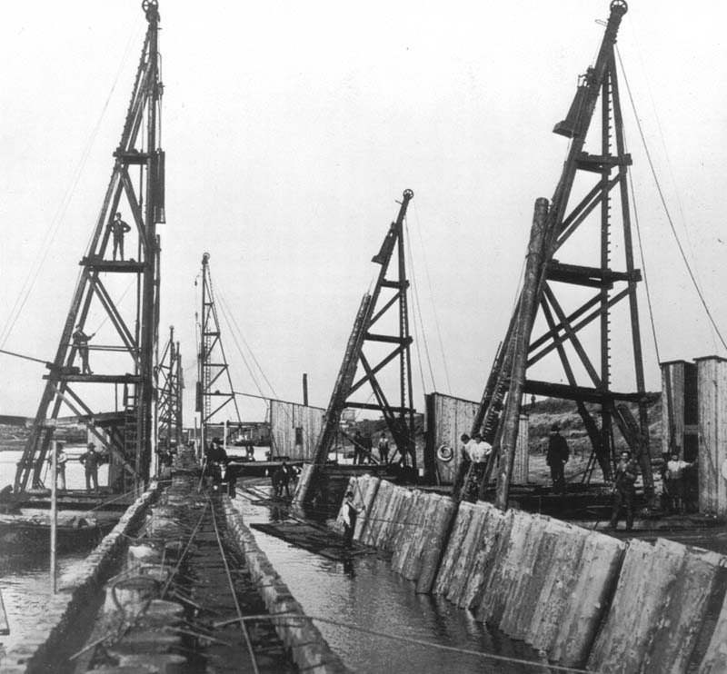
Fig. 36. Pile driving works at the Weserkorrektion, c.1889. Source: Commons.
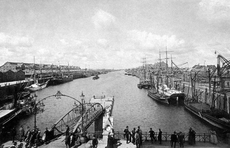
Fig. 37. The Bremen free port, c.1914. Source: Commons.
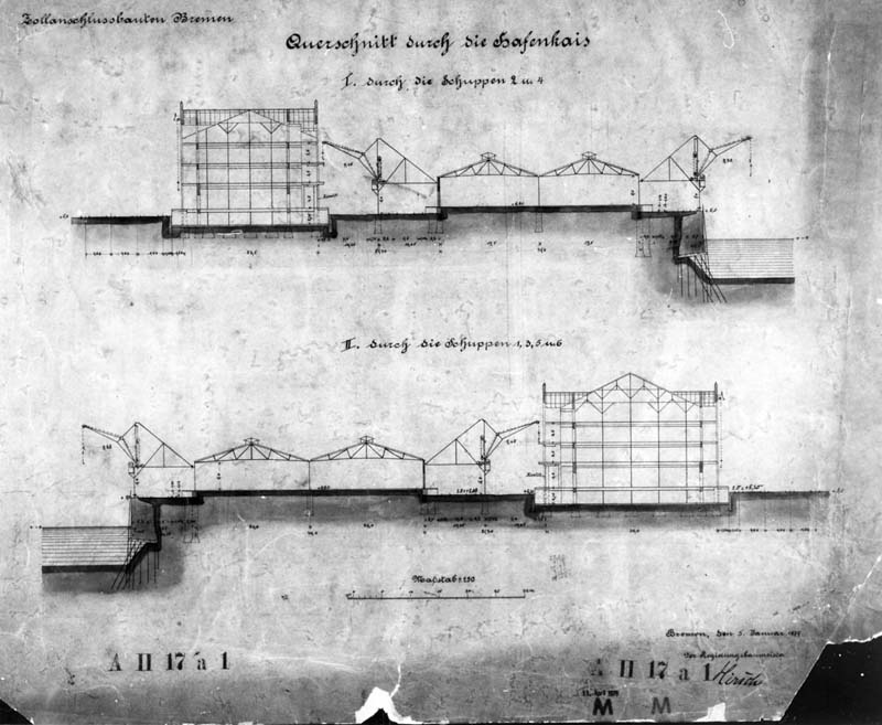
Fig. 38. Section through the harbor quay and warehouses in the Bremen free port. Source: Regierungsbaumeister, Zollanschlussbauten Bremen, Querschnitt durch die Hafenkais, 1879. Lilli Hasche, Janne Jensen, Katrin Amelang and Silke Betscher, “3. Baumwollhandel,” Ankerpunkte der Verflechtung: postkoloniale Spuren in der Bremer Überseestadt (Audio-Guide), accessed 10 November 2023, https://ankerpunkte.ak-hafen.de/.
Common to both the establishment of the DSPAG’s mining activities on Angaur and the expansion of the Norddeutscher Lloyd as a vertically integrated corporation was the comprehensive rationalization of the Weser River. Between 1886 and 1895, the hydrological engineer Ludwig Franzius led the so-called Weserkorrektion (Weser correction)—a major project undertaken by the Free Hanseatic City of Bremen to regularize the flow and increase the depth of the Weser (figure 35). Centuries of agricultural expansion and subsequent erosion had, by the nineteenth century, caused sufficient siltation to prevent vessels from reaching the unloading and storage facilities in Bremen, which presented a commercial disadvantage for the city in its competition for trade with nearby Hamburg. Subsidiary harbors had been purchased and developed by Bremen downriver at Vegesack (1671) and Bremerhaven (1830) to combat this issue, requiring all goods to be loaded onto barges before being transported upriver. As Franzius notes in his Korrektion der Unterweser (1888): “The aim is to improve the entire upper tidal area above Bremerhaven in such a way that the newly created conditions are maintained by the increased and regulated currents [...] and that the lower tidal area will also experience an improvement as a result of the increased inflow of flood water.”30 To achieve these increases in volume, current and depth, a dredge was used to remove 30 million cubic meters of sand from the riverbed of the Weser; curves were straightened by ramming timber piles into the soft banks and backfilling excavated material; and the edges along the entire length of the river north of Bremen were reinforced by foundation walls and breakwaters using 1.2 million cubic meters of imported stone (figure 36). Gradually, the Weser was transformed into a heavily engineered canal between Bremen and the North Sea along which large seagoing vessels with drafts of up to five meters could safely navigate all the way to the Europahafen (Europe Harbor)—declared a free port in 1888—and the later Überseehafen (Overseas Harbor) near the city center (figure 37). Here, the throughput of the logistical system designed by Franzius was accelerated further. Warehouses on long quays up to 400 meters in length were set back from the harbor edge by rail lines and flexible semi-gantry cranes. Goods could be loaded directly into waiting trains or stored in the multi-story warehouses for later distribution and transshipment (figure 38). Together, these measures were referred to as the “Bremer System,” devised to minimize cost by maximizing the speed of handling.31 To manage the operation of this system the city’s merchants established a port authority known as the Bremer Lagerhausgesellschaft (Bremen Warehouse Society), which continues to operate as BLG-Logistik today—a venture in which the city of Bremen holds a controlling interest.32
The Weserkorrektion secured Franzius’ international reputation in hydraulic engineering circles. In 1901, he submitted a proposal for the regularization of the Huangpu River in Shanghai in collaboration with the American engineer Lindon W. Bates. In Bates’ 1905 proposal for the Panama Canal, he celebrated his German colleague, declaring that “the world is indebted to [Ludwig Franzius], whose monumental success on the Weser attests to the genius which won an erratic river to a regular flow.”33 As argued in the walking tour audio guide produced by the Arbeitskreis Hafen Bremen (Working Group Bremen Harbor), the Weserkorrektion and the Bremer System are also indicative of the significance of maritime infrastructure as a fundamental technical and commercial mode through which German colonialism was advanced:
On the West African coasts, the German Imperial Government commissioned maritime infrastructure to meet the needs of colonial merchants and the logistical requirements of the so-called “Protection Forces” (Schutztruppen), for example by the Franconian engineering group MAN. In Kiautschou Bay, on the east coast of China, the Imperial Navy developed a harbor colony with the help of the Hamburg construction company Fehring on the recommendation of Ludwig Franzius’ younger brother. [...] The colony was conceptualized as an experimental space where hydraulic engineering methods and techniques could be tested under ideal conditions. In this respect, the Weserkorrektion was neither the sole concern of competing neighboring cities, nor can it be adequately understood as the intellectual accomplishment of a single engineer. Rather, the biographies of the Franzius brothers make it clear that the colonial project not only gave Hanseatic merchants the opportunity to expand their commercial activity, but also served as a practical field of innovation for engineering science and industrial manufacturing, both in colonial territories and in the metropole.34
Insofar as the Schutzgebiet was an administrative form suited to the extractive logic of German colonialism it also presented a series of technical problems—both at home and abroad—that relied on the engineering expertise and infrastructural intervention promoted and enacted by the likes of Franzius, Wiegand, F. H. Schmidt and Dernburg. As one such example, the Weserkorrektion remained central to the commercial interests of the Norddeutscher Lloyd and the DSPAG in particular: close to sixty percent of the early rock phosphate exports from Angaur were shipped along the corrected Weser River to Bremen on Lloyd vessels prior to distribution to superphosphate manufacturers. The closest such manufacturer was the Superphosphatfabrik AG Nordenham, which had also been established by the Norddeutscher Lloyd in 1906 as yet another of the Wiegand industries, anticipating phosphate imports from its mining activities on Angaur. The factory complex in Nordenham was located upriver from Bremen, on the opposite side to Bremerhaven, and provided superphosphate fertilizer to the extensive agricultural districts of Lower Saxony. As fate would have it, the company ultimately merged with Ohlendorff’s former Anglo-Continental Guano Works in the mid-twentieth century, becoming Guano-Werke AG.
As Dixon argues, chemification is characterized by a simultaneous extension into resource and labor frontiers (Chincha Islands, Malden Island, Lacepede Islands, Nauru, Angaur, Banaba, Christmas Island, Makatea), and a concomitant consolidation and intensification of industrial power in urban-imperial centers (Hamburg, Bremen, London, Melbourne, Adelaide, Auckland, Wellington). Reflecting on the German superphosphate industry in 1913, the chemical engineer Carl Elschner discerned this intensification in the transition from the “once primitive facilities” found during the time of Ohlendorff’s early guano works in Hamburg to the “highly developed superphosphate factories” such as the Superphosphatfabrik AG Nordenham. The latter factories now boasted “larger, ventilated storage and working spaces, rationalized crushing facilities with increased capacity,” in addition to widespread automation and mechanization of the production process. The modernization of the superphosphate industry, Elschner argued, was on par with the successes of the more celebrated chemical industries in Germany—especially paints and pharmaceuticals—for which the country had become known in recent decades. “If one were to briefly consider the history of the superphosphate and artificial fertilizer industry, especially in the last thirty to forty years,” Elschner hypothesized:
then I imagine one would come to the conclusion that it readily sits alongside the other branches of German chemical engineering—indeed, I would like to assert that it far surpasses them all, even if the majority of the German people have no real idea of the tremendous value that fertilizers represent annually and, much less, of the incalculable increase in the monetary value of our agricultural products that have been achieved as a result of the German artificial fertilizer industry.35
But the value of this industry went beyond simply increasing agricultural production in Germany. It had delivered significant returns to the Reich in the form of phosphate mining royalties raised in the Schutzgebiete; it had provided opportunities for German architects, construction companies and engineers to expand their professional spheres of activity; and it had contributed to the industrialization and modernization of waterways and urban precincts in Bremen and Hamburg. In the process, it had precipitated German corporations’ effective self-government of resource colonialism and prompted the state to formalize its approach to the acquisition of colonial territory. As Anneliese Scharpenberg and Hartmut Müller have argued, no German colonial-political measures were adopted in the phosphate industry “that would have incentivized exportation to the motherland and thus shifted the market position in favor of European sales.” Instead, trade relations in German Micronesia “were governed exclusively by global economic considerations,” influenced by factors such as comparative freight costs, more recent discoveries of phosphate deposits closer to Europe and the introduction of new types of synthetic fertilizer.36 The gradual shift of rock phosphate exports from Angaur and Nauru towards the Japanese and Australian markets in the early twentieth century was therefore the inevitable outcome of fluctuations in the world phosphate market. This was also entirely by design; the result of the administrative form and entrenched infrastructuralism of German colonial policy and its foundation in the market-based structures of Hanseatic imperialism (figure 39).
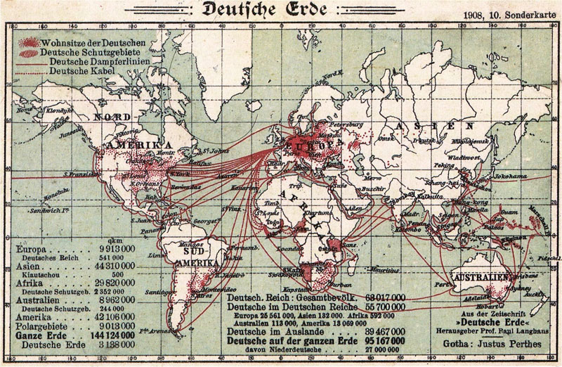
Fig. 39. Map showing German settlements, Schutzgebiete, shipping routes and telegraph cables. Source: Paul Langhans, Deutsche Erde (Gotha: Justus Perthes, 1908), map 10.
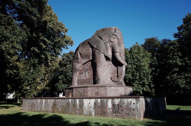
Fig. 40. The Antikolonialdenkmal—also known as “the elephant”—in Bremen’s Nelson Mandela Park.
In Bremen’s Nelson Mandela Park—which feeds into the larger Bürgerpark that was partially funded by Heinrich Wiegand and the Norddeutscher Lloyd—I stumble across a large masonry elephant known as the Antikolonialdenkmal (Anti-colonial Monument). After starting life as the Reichskolonialehrendenkmal (Imperial Colonial Monument) in 1931 to promote the reacquisition of German colonies, the statue was rededicated in 1990 to commemorate Namibia’s independence (figure 40). The elephant cuts a more imposing figure than the Ohlendorff lion in Blohms Park in Hamburg, and, also unlike the lion, the elephant is appended by a plaque outlining the changing perceptions of German colonialism in the city of Bremen. Facing the elephant, the Weser River lies behind me. I follow its course in my mind: from the warehouses in the old Überseehafen, along its regularized edges, past the former sites of the Wiegand industries at Vegesack and Nordenham before draining into the North Sea. I imagine something similar for each of the phosphate ports in Australia and New Zealand: thousands of ever-larger ships plying the Indian and Pacific Oceans and the Tasman, Coral and Philippine Seas, descending on two small islands in Germany’s Pacific Schutzgebiete. If I cannot find any mention—let alone memorialization—of the colonial history of Nauru and Angaur in Germany, I am curious what I will find on the islands themselves, which is where my travels will take me next.
1 Hans Joachim Schröder, Heinrich Freiherr von Ohlendorff: Ein Hamburger Kaufmann im Spiegel der Tagebücher seiner Ehefrau Elisabeth (Hamburg: Hamburg University Press, 2014), 32–36.
2 Lola Loustaunau, Mauricio Betancourt, Brett Clark and John Bellamy Foster, “Chinese Contract Labor, The Corporeal Rift, and Ecological Imperialism in Peru’s Nineteenth-Century Guano Boom,” The Journal of Peasant Studies (2021), 11.
3 “Historische Bleiplomben,” Heimat- & Geschichtsverein der Gemeinde Nörvenich e.V., accessed 10 November 2023, https://www.hgv-noervenich.de/arbeitskreise/bleiplomben.
4 Marion W. Dixon, “Chemical fertilizer in transformations in world agriculture and the state system, 1870 to interwar period,” Journal of Agrarian Change 18 (2018), 783.
5 Jason W. Moore, Capitalism in the Web of Life: Ecology and the Accumulation of Capital (London: Verso, 2015), 150.
6 Ralf Lange, “Vor dem Spiegel,” Quartier: Magazin für HafenCity, Speicherstadt und Katharinenviertel, accessed 10 November 2023, https://archiv.quartier-magazin.com/quartier09/vor-dem-spiegel.
7 “Dovenhof: Hamburgs erstes Kontorhaus,” Welterbetour, accessed 10 November 2023, https://www.welterbetour.de/author/admin/page/8.
8 The organizations include: Eine Welt Netzwerk Hamburg, Hafengruppe Hamburg, Arbeitskreis Hamburg Postkolonial, Grenzgänger and St. Pauli Archiv.
9 Heiko Möhle, “Kolonial-Spaziergang,” in Hamburg: 20 thematische Spaziergänge (Hamburg: Junius Verlag, 2009), 189.
10 Sebastian Conrad, German Colonialism: A Short History (Cambridge: Cambridge University Press, 2012), 25.
11 Cait Storr, International Status in the Shadow of Empire: Nauru and the Histories of International Law (Cambridge: Cambridge University Press, 2020), 56.
12 Möhle, “Kolonial-Spaziergang,” 189.
13 Ibid.,180. My translation.
15 See Kim Sebastian Todzi, “Die Handelskammer Hamburg als Kolonialer Erinnerungsort,” University of Hamburg, accessed 10 November 2023, https://kolonialismus.blogs.uni-hamburg.de/2021/12/23/die-handelskammer-hamburg-als-kolonialer-erinnerungsort/. See also Jürgen Zimmerer and Kim Sebastian Todzi, Hamburg: Tor zur kolonialen Welt (Göttingen: Wallstein Verlag, 2021).
16 Adolph Woermann, “Denkschrift der Handelskammer über die deutschen Interessen in West-Afrika,” in Das Staatsarchiv: Sammlung der offiziellen Aktenstücke zur Geschichte der Gegenwart, ed. Hans Delbrück, vol. 43 (Leipzig: Dunker & Humblot, 1885), 236–37. My translation.
18 Jasper Ludewig, “Securing Territory: Grey Architecture and the German Missions of the Cape York Peninsula, 1886–1919” (PhD diss., University of Sydney, 2020), 28, fn. 53.
21 Joshua Barkan, Corporate Sovereignty: Law and Government under Capitalism (Minneapolis, MN: University of Minnesota Press, 2013).
22 Stewart Firth, “German Labour Policy in Nauru and Angaur. 1906–1914,” The Journal of Pacific History 13, no. 1 (1978), 37; 51.
23 “Agreement between the Jaluit-Gesellschaft and the Reich,” Marshalls Digital Micronesia, ed. Dirk Spennemann, accessed 10 November 2023, https://marshall.csu.edu.au/Marshalls/html/history/JaluitContract.html.
24 Peter Hempenstall, “Die deutsche Kolonialherrschaft in Ozeanien: Eine vielfarbige internationale Geschichtsschreibung,” in Aus Westfalen in die Südsee: Katholische Mission in den deutschen Kolonien, eds. Silke Hensel and Barbara Rommé (Berlin: Dietrich Reimer Verlag, 2018), 143.
27 F. H. Schmidt, Bauunternehmung, Hamburg, Altona, Harburg-Wilhelmsburg, Buenos Aires, c.1930, Deutsches Museum, FS 505593-2.
28 “F. H. Schmidt, Bauunternehmung, Altona, Hamburg, Tsingtau,” Historisch-biographische Blätter: der Staat Hamburg 7 (1905/6), Staats- und Universitätsbibliothek Hamburg.
29 Quoted in Anneliese Scharpenberg and Hartmut Müller, “Die Deutsche Südseephosphat-Aktiengesellschaft Bremen,” Bremisches Jahrbuch 55 (1977), 141. My translation.
30 Ludwig Franzius, Die Korrektion der Unterweser: auf Veranlassung der Bremischen Deputation für die Unterweserkorrektion (Bremen: Guthe, 1888), 8. My translation.
31 Georg Skalecki, “Speicherbauten in Bremen,” in Stadtentwicklung zur Moderne: die Entstehung großstädtischer Hafen- und Bürohausquartiere, ed. Frank Pieter Hesse, ICOMOS Hefte des Deutschen Nationalkomitees 54 (Berlin: Hendrik Bäßler Verlag, 2012), 82.
32 Lilli Hasche, Janne Jensen, Katrin Amelang and Silke Betscher, “3. Baumwollhandel,” Ankerpunkte der Verflechtung: postkoloniale Spuren in der Bremer Überseestadt (Audio-Guide), accessed 10 November 2023, https://ankerpunkte.ak-hafen.de/.
33 Lindon W. Bates, The Panama Canal: System and Projects (Washington, DC: US Government Publishing Office, 1905), 65.
34 Lilli Hasche, Janne Jensen, Katrin Amelang and Silke Betscher, “2. Koloniale Infrastrukturen,” Ankerpunkte der Verflechtung: postkoloniale Spuren in der Bremer Überseestadt (Audio-Guide), accessed 10 November 2023, https://ankerpunkte.ak-hafen.de/. My translation.
Leave a commentOrder by
Newest on top Oldest on top