-
Conferences
Conferences
SAH Annual International Conferences bring members together for scholarly exchange and networking
-
Publications
Publications
Through print and digital publications, SAH documents the history of the built environment and disseminates scholarshipLatest Issue:
-
About
About
SAH promotes the study, interpretation, and conservation of the built environment worldwide for the benefit of all

On Layering: Surviving Angaur
Mar 13, 2024
by
Jasper Ludewig, recipient of SAH's H. Allen Brooks Travelling Fellowship
Getting to Angaur involved chartering one of the hundreds of small boats scattered around the Republic of Palau. After approaching the main operators in Koror—the commercial and tourism center of the archipelago—I eventually found a captain open to the prospect of a day trip to the remote island (figure 1). (He shall remain nameless in this report for reasons that will become obvious below). Leaving Koror on the morning of our voyage, which had been rescheduled several times due to high winds and large swell, we made a brief detour to collect a young resident of Angaur returning home with fuel and fresh vegetables. As he boarded, he explained that he was excited to finally be getting back to his family after the recent bad weather had kept him away longer than expected. Conversation fell away as we left the harbor and the captain brought the two engines into life, the boat lurching forwards before rising to skim across the surface of the water. We quickly settled into the two-hour passage to Angaur (figure 2).
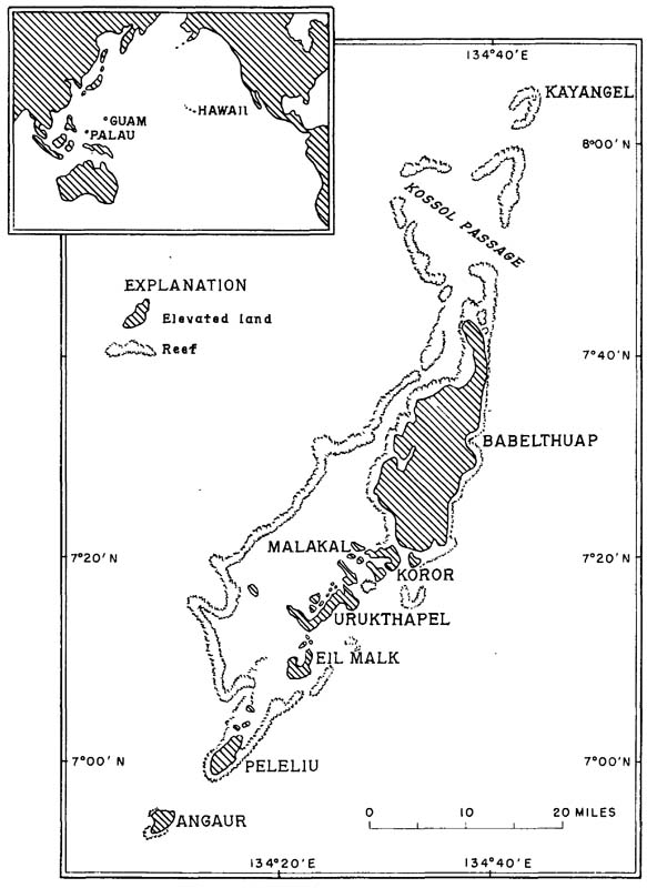
Fig. 1 – Map of the Palau archipelago with inset indicating its position in the Pacific Ocean. Source: Ted Arnow, Effects of Phosphate Mining on the Ground Water of Angaur, Palau Islands Trust Territory of the Pacific Islands, Geological Survey Water-Supply Paper 1608-A (Washington, D.C.: United States Government Printing Office, 1961), 4.
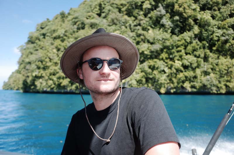
Fig. 2 – When spirits were still high: on the way to Angaur from Koror by boat.
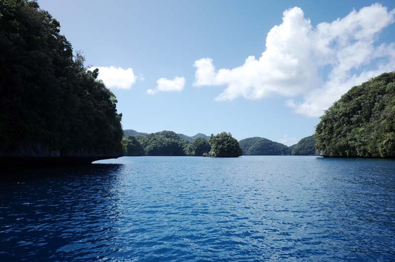
Fig. 3 – Several hundred Rock Islands rise from the large lagoon that stretches between Babeldaob and Peleliu. Their slight overhangs give the impression that they are floating above the surface of the water.
Our route took us south, via the Rock Islands—large polyps of limestone that appear to float above the turquoise lagoon, covered in verdant green (figure 3)—before heading through German Channel, blasted out of the coral reef in the early twentieth century, when Palau was a German colony, to facilitate a quicker connection between Angaur and Koror (figure 4). Leaving the channel, we hit open water for the first time and proceeded south along the western coastline of Peleliu. Large rollers passed beneath us, bobbing our small boat up and down before jagging steeply upwards and exploding onto the island’s low reef. Each explosion produced a salty mist that slowly drifted back out to sea, engulfing us and turning the morning sky into a sheet of white light. The dark contours of Angaur’s northern cliffs gradually began to emerge from the glare, disappearing and reappearing again as we undulated across the ocean (figure 5). The captain had announced his intention to troll through the deeper water between Peleliu and Angaur and his deckhand was soon summoned to deploy a spread of flamboyant lures in the hopes of enticing a passing wahoo or yellowfin tuna.
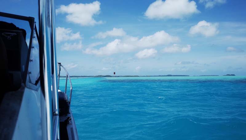
Fig. 4 – A marker indicates the entry to German Channel on the way to Angaur from Koror.
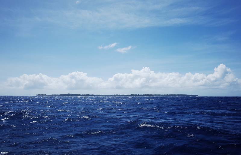
Fig. 5 – Angaur seen between sets of waves from the northern channel that separates it from Peleliu.
The swell was enormous. As we poked our nose around the southern tip of Peleliu the waves rose to three, perhaps four times what they had been on the protected western side of the island: vast mounds of bulky, angry water ripping across the bow; accelerating, rising and collapsing in sharp claps at random intervals; a confused and violent surface above an abyss the depths of which I preferred not to fathom. The lures were eventually brought in as we reached the northern tip of Angaur, our only catch being a sad strip of seaweed dislodged from the nearby cliffs by the powerful swell. I seemed to be the only one unsurprised by our failure to extract a fish from the churn, but it was agreed that there would be another opportunity on the way home, hopefully with less swell and a better wind direction. Thus, spirits remained high on the resilient little boat, as did my heartrate, which, according to my smartwatch, was racing at 100 BPM as we entered the harbor at Angaur; a situation not helped by the group of locals assembled on the rocks, their phone cameras out, filming the uncommon spectacle of a tourist boat in the heavy seas (figure 6).
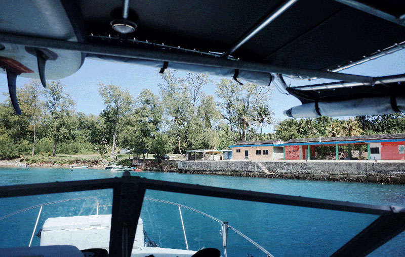
Fig. 6 – The boat harbor at Angaur upon our arrival. Note all the locals’ boats: no one was out fishing in the dangerous conditions on this day.
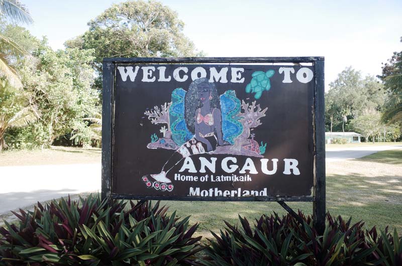
Fig. 7 – “Welcome to Angaur: Home of Latmikaik, Motherland,” reads the sign at the boat harbor.
Palau was formed within a complete, closed universe after the sky god, Ucheliangl, made land rise from the turbulent stretch of water we had just crossed between Angaur and Peleliu. Latmikaik, a giant pregnant clam, then gave birth to half-fish, half-human children whom she instructed to pile rocks from the seabed to the sky before toppling them over to create Palau’s many rock islands. On their northward journey from Angaur, Latmikaik’s children discovered fire and were taught carpentry and measurement by the underwater gods. One such child, Chuab, was tasked by Ucheliangl with bestowing social order upon the archipelago. She passed this task on to her own children who again proceeded from Angaur in the south, creating chiefly councils on their way to Babeldaob, the northernmost island of Palau. Our trip had thus effectively transported us backwards in cosmological time: to the site where the cosmic migration from the world under the sea first made landfall and from which the social structure for a future Palauan polity was established (figure 7). 1 Western science estimates that this polity began to arrive—initially from Indonesia and then the Philippines—approximately 3,000 years ago. Large earth structures on Babeldaob, some close to 2,500 years old, attest to the intensity of the first colonists’ occupation, hosting agricultural, infrastructural, domestic and ceremonial functions, and defining the political space of Palau for over a millennium. 2
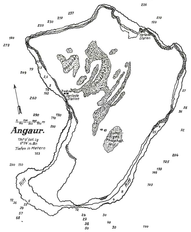
Fig. 8 – Map of Angaur showing the different phosphate deposits on the island (hatched). The German South Sea Phosphate Company’s drying and loading facilities are located on the west coast and an additional loading station is situated on the northern cliffs. Source: Carl Elschner, Corallogene Phosphat-Inseln Austral-Oceaniens und ihre Produkte (Lübeck: Max Schmidt, 1913).
No such structures were developed on the low-lying, isolated island of Angaur, which stretches to only four kilometers in length and approximately the same in width, sloping down from its raised edges in the north towards the once swampy land at its center. It was here that District Commissioner Arno Senfft first discovered phosphate in 1905, six years after Palau had been sold to Germany by Spain as part of the Caroline Islands following the Spanish-American War. The deposits Senfft unearthed boasted two distinct types of phosphate: a reddish-brown and grainy variant located close to the surface, between the island’s limestone pinnacles; and a white phosphate found in continuous blankets beneath the swamps (figure 8). 3 As on Christmas Island and Nauru, Angaur’s phosphates were the product of a fusion between limestone, soil and seabird excrement, formed over millennia and to an extremely high grade.
In the year after Senfft’s discovery, the Bremen-based Norddeutscher Lloyd shipping company arranged for an inspection of the island by Wilhelm Schönian—the same mining engineer who had overseen the development of the Pacific Phosphate Company’s early facilities on Nauru. As discussed in my third report, this followed the entreaties of Albert Hahl, governor of German New Guinea, who viewed mining as a lucrative way to encourage private development throughout his vast protectorate. The Angaur deposits were estimated at around 2.5 million tons of eighty-six percent phosphate of lime, speaking favorably for a mining venture. The Deutsche Südseephosphat Aktiengesellschaft (German South Sea Phosphate Company Limited, DSPAG) was subsequently formed in 1908 with Schönian as its technical director. 4 A contract soon followed that at once transferred the ownership of Angaur from eight “island chiefs” to the treasury of German New Guinea, while also granting the DSPAG exclusive mining and settlement rights over eighty percent of the island. This confined the local population to a 150-hectare reserve in the southeastern corner of the island in return for a one-off payment of £60. 5
The testimony of Chief Uherbelau, whose reign commenced in 1908 when he inherited the position from his mother, recounts a different version of events leading to the original phosphate mining lease. In a letter from the 1940s to the US administration in Palau, Uherbelau describes how the Germans, having realized the value of the phosphate deposits on Angaur, refused to negotiate with his mother, claiming they were unable to conduct business with a woman. Instead, they escorted a group of local men to Koror where, at gunpoint, they were coerced into signing the agreement. Presumably, these men were the “island chiefs” whose signatures are recorded on the original contract. When Uherbelau’s mother later proposed that her community should receive royalties from the mining, the DSPAG refused to recognize her title as chief altogether. Once Uherbelau was appointed in her place, she was summarily sent over five hundred kilometers away to the center of the German administration in Yap in the Western Caroline Islands. 6 Thus supposedly unencumbered, the DSPAG commenced its operations on the island in February of 1909, bringing twenty-three European employees, fifty-five contracted Chinese craftsmen and ninety-eight indentured laborers from Yap. This involved dividing the island into thirds and moving the local population from numerous villages—Ngerbelau, Ngebeanged and Rois—to the reserve established in the Ngermasech region in the southwest (figure 9). 7
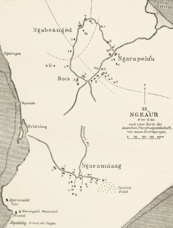
Fig. 9 – Map from c.1915 depicting the traditional villages of Angaur. The reserve created in the Ngermasech (Ngaramasag) region is shown in the south, beneath which are the buildings of the DSPAG. Source: Augustin Krämer, Palau, vol. 3 (Hamburg: L. Friederichsen & Co., 1919), 286.
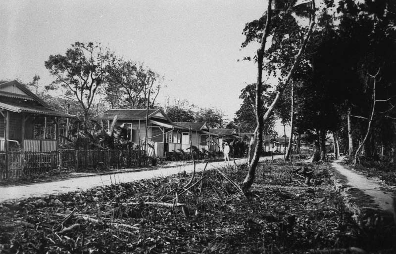
Fig. 10 – Prefabricated housing for the European employees of the German South Sea Phosphate Company on Angaur, supplied by the Hamburg-Altona-based company F. H. Schmidt, c.1909. Source: Deutsches Bundesarchiv, Sammlung Heinrich Hagedorn, Bild 223-158.
A further 126 men were indentured from the Central Caroline Islands over the course of 1909, tasked with erecting the prefabricated facilities manufactured by F. H. Schmidt in Hamburg-Altona, and to commence the mining operations. 8 They worked nine hours per day, six days a week and received a monthly wage equivalent to around $4 USD. 9 The initial shipments of equipment and materials from Bremen and Hamburg amounted to a full arsenal of locomotives, wagons, rails and sleepers, water treatment facilities, as well as the electrical and transmission devices required to establish a radio connection with Yap. In addition, F. H. Schmidt provided a suite of prefabricated timber buildings including a director’s house, houses for the managers of the phosphate works, government officials, overseers, workers’ dormitories, transportable warehouses, a hospital, a separate mess hall for DSPAG officials and workers, a kitchen, office building, laboratory and goods stores (figure 10). 10 A casino was also erected for the entertainment of the officers in the evenings, containing a bowling alley, billiard table and piano. Therefore, within a year of securing a mining lease over Angaur, the DSPAG had established a large company settlement and a functional phosphate mine on the most remote island in the Palau archipelago.
The next four years saw a substantial shift in the proportions of the different groups on Angaur: European staff dropped by half to only ten; Chinese workers doubled to one hundred; and Caroline Islanders increased fourfold to five hundred. 11 As David Hanlon notes, the abuse of the laborers brought to the island by the DSPAG included:
low wages, frequent payment in the form of near worthless coupons rather than currency, forced purchases with these devalued coupons of overpriced goods in the mining company’s store, physical punishment and extended working hours. By 1911, the situation had deteriorated so badly that German colonial officials elsewhere in the Carolines were refusing to assist in the recruitment of islander labor for Angaur. 12
Instead, one hundred prisoners were brought to the island as convicts under police guard in 1911 following the suppression of a rebellion against German rule in Pohnpei. The DSPAG’s exploitation of cheap labor minimized operational costs, enabling it to invest in major capital works upgrades on the island as early as 1910. 13 As a result, annual exports from Angaur climbed by four hundred percent: from approximately 9,000 tons of in 1909, to more than 36,000 tons in 1910, before continuing to rise to 89,000 tons in 1913. 14 As noted by the geologist John Rodgers, of the many phosphate islands in the Western Pacific, “only Angaur has produced on a scale at all comparable with the outstanding Pacific island deposits: Nauru and [Banaba], northeast of the Solomon Islands, and Makatea, north of Tahiti.” 15
Michael 16, my tour guide on Angaur, was sheepish when I asked him how safe he thought it was for us to have made the crossing from Koror. “I thought you were the coast guard” was all he offered, politely suspending any overt judgement of our captain’s decision to make the trip while also implying, unmistakably, that no normal boat or person should have hazarded the ocean that day. My teeth clenched as I imagined the homeward passage to Koror. I jumped onto the back of Michael’s small truck and, as we headed for our first stop on the tour, I focused on bringing my heart back down to its resting rate. Deep breaths and happy places. I soon remembered why I had made the trip to the island and reached for my phone, bringing up the maps and old photographs I had prepared for Michael the night before. Once my enthusiastic show-and-tell had drawn to a close he shot me a look of concern: “Yes, all this was once here, but it’s gone now.” “You mean there’s nothing for me to see?” my voice climbing to a falsetto. “That’s right…” I immediately recommenced my breathing exercises, warding off the intrusive thought that I had made the long journey—Sydney, Brisbane, Port Moresby, Koror, Angaur—in vain. Sensing disappointment, or perhaps thinking I was about to faint, Michael quickly added: “But let’s go and have a look anyway.”
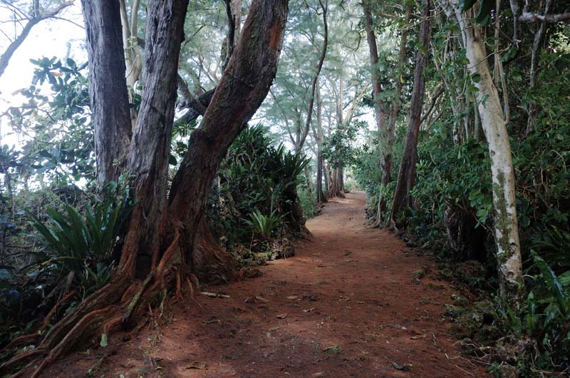
Fig. 11 – The ring road on Angaur closely follows the coast, passing through fields of tall limestone outcrops, small beaches, pine forest and exposed cliffs.
The truck bounced along a road that had been cut into the scrub, wending its way between weathered outcrops of limestone as it followed the coast (figure 11). Macaque monkeys scurried across our path, disappearing into the knotted canopy above. I had expected them, having read they were the descendants of an original pair of macaques introduced to Angaur by German mining engineers to monitor air quality in the early mines. 17 The monkeys were, in this sense, the first evidence I encountered of the former phosphate industry’s presence on the island. We next passed Diai in the northwest, a blowhole rumored to have extinguished the firebird Esisbangiau, sent from Peleliu to incinerate Angaur during the warring times. 18 I heard its deep exhalations before I saw its column of seawater rising through the pine trees, cresting waves and a mess of whitecaps visible in the channel beyond. As we approached a non-descript section of road, Michael brought us to a slow halt. I scanned the thick vegetation, seeing nothing of note. “Here we are,” he announced as I jumped off the truck, preparing myself for whatever disappointment lay ahead. But then, as we trudged across the boggy ground, the tangle of vines and branches began to tessellate into an orthogonal shape: not vines, but the corroded webbing of a steel truss; not a branch, but a steel beam, collapsed into the liquid trunk of a strangler fig (figure 12). Like the spine of some giant beached whale, I began to discern the form of a once massive linear structure receding into the interior of the island (figure 13). This, I knew, was the phosphate processing plant of which Michael had told me there were no remnants. I briefly locked eyes with him and his bemused smile let me know that he had played me for a fool. I contemplated an appropriate quip in response; however, relief is a magnanimous emotion and all I could muster was: “This is incredible.”
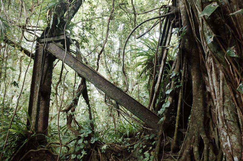
Fig. 12 – The steel structures of the former phosphate facilities are being consumed by the thick jungle of the island’s interior.
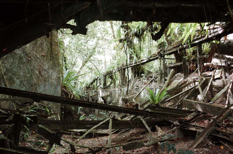
Fig. 13 – Remnants of the former phosphate mill and dryer lead from the inland phosphate pits on Angaur to the loading facilities on the coast.
We spent the next hour clambering over wafer-thin corroded steel members, into brick kilns, beneath rotary dryers and along the length of the extensive ruins. Old phosphate was still stuck to the fins inside the rotating drums of the dryers. Staghorn grew from the chutes and buckets laying around. Damp bricks resisted their inevitable return to the earth (figures 14 – 16). I tried to piece together and distinguish the different infrastructural layers from the collapsed mess around us. I knew the steel we had seen as we arrived was from the so-called “Gute Hoffnungshütte,” a hulking 18-meter-wide by 18-meter-high, 100-meter-long, two-story integrated processing facility prefabricated in Germany and erected on Angaur by the DSPAG around 1912 (figure 17). (I later learned that the structure is now referred to by locals as Blailebakl [adz house] in reference to the repurposing of its steel to make adzes and other hand tools). 19 Damp phosphate was conveyed to its upper level by a cable railway before being dropped into large driers heated by furnaces from the level below, fueled using felled timber from the old growth forest on the island. Once dried, the export-ready product was stored in the enclosed structure, alongside workshops, a forge and storage space for the DSPAG’s five locomotives, which plied around ten kilometers of tracks on the island leading from the mining sites in the interior to the processing facilities and ultimately to the harbor installations on the coast.
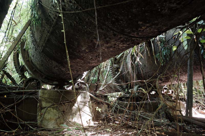
Fig. 14 – The undersides of the rotary dryers used to reduce the moisture content of the phosphate prior to export. White phosphate was still stuck to the insides of the drums, seventy years after mining ceased.
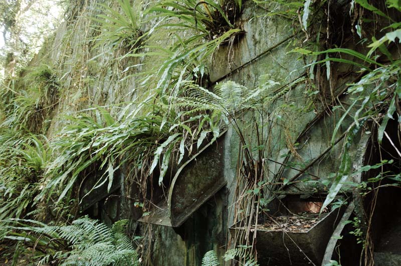
Fig. 15 – Staghorn and ferns grow from the hoppers and chutes of the phosphate loading and storing bin.
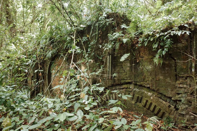
Fig. 16 – A brick kiln, built by the DSPAG and used to heat the rotary driers shown in figure 14, threatens collapse. The circular shape to the left of the image is the manifold that was used to attach the drums to the kiln.
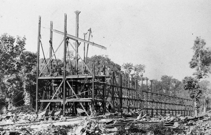
Fig. 17 – The Gute Hoffnungshütte under construction in c.1912. Source: Deutsches Bundesarchiv, Sammlung Heinrich Hagedorn, Bild 223-227.
More surprising was the tall concrete structure—likely a later phosphate storage bin—located immediately adjacent to the former Gute Hoffnungshütte (figure 18). We entered via its western façade, the afternoon light streaming in to illuminate a walled garden seemingly draped over the industrial skeleton (figure 19). Ficus roots and other creepers dangled through the open roof, curling themselves around the rectangular columns. Internal buttresses reinforced engaged columns along the walls, perhaps also acting as bulwarks to break up the masses of phosphate once stored in the space (figure 20). I asked Michael if he knew whether the structure was German, Japanese or American—these being the three administrations involved in working the phosphate on the island over the course of the twentieth century. He replied that he was unsure. I later came across photos taken in the days following the US seizure of the island during the Battle of Angaur in 1944 (figure 21). They revealed that the concrete structure pre-dated the American occupation of the island, suggesting it had been constructed during the period in which Palau was administered as part of the South Seas Mandate after Japan purchased the mining rights and equipment from Germany in the aftermath of World War One. The photos also captured an elaborate conveyor system on the coast used to load ships in deeper water beyond Angaur’s shallow reef, presumably erected by the South Sea Development Company (Nan’yo Kohatsu, KK)—the largest single commercial operation in Micronesia during the inter-war period—which took on the phosphate mining operations on Angaur in the 1920s alongside its other enterprises in sugar, alcohol, resin, cotton, palm, copra and fisheries. 20
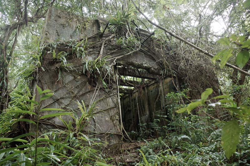
Fig. 18 – The entry to the concrete phosphate storage bin, located directly next to the ruins of the Gute Hoffnungshütte.
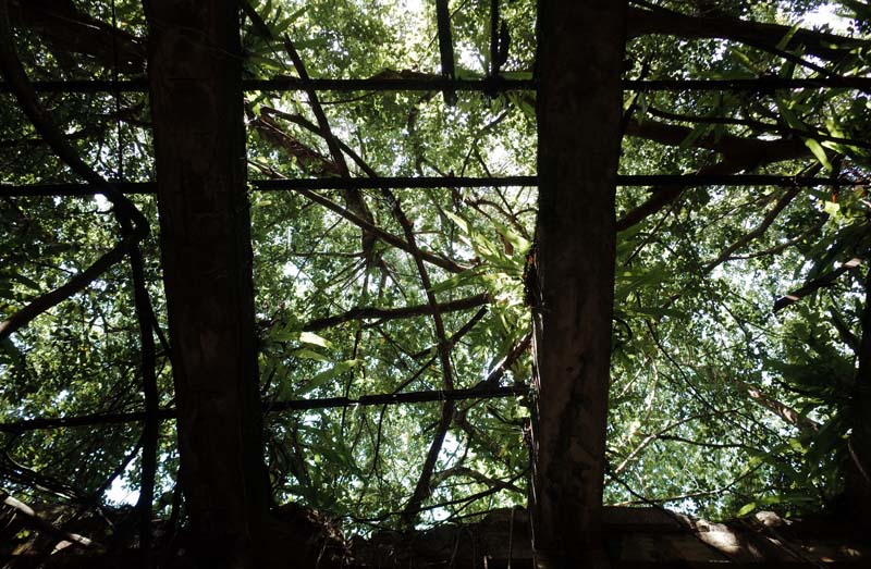
Fig. 19 – The view looking up from the within the phosphate storage bin.
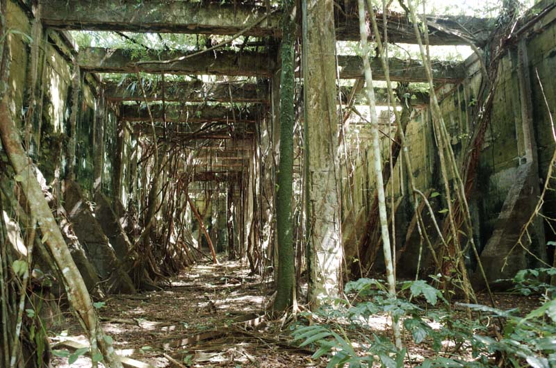
Fig. 20 – Trunks and roots now obscure the rhythm of the concrete structure.
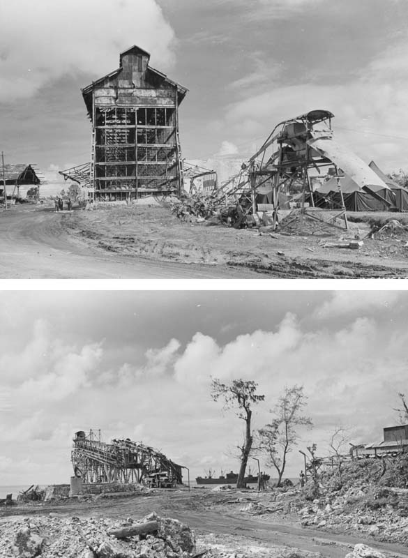
Fig. 21 – Photos taken following the Battle of Angaur in 1944 showing the partially destroyed Gute Hoffnungshütte and concrete storage bin behind (top) and the remnants of the cantilever and conveyor system used for loading ships in deeper
water beyond the fringe reef (bottom). Source: US National Archives, Caroline Islands, 1944, 204970791.
Leaving the main processing facilities, we passed the remains of a second loading arm, built into the northeastern cliffs of the island by the DSPAG and designed for use when conditions were unfavorable at the boat harbor on the western side (figure 22). We continued in a clockwise direction, passing limestone caves in which locals had sheltered during the American bombardment of the Japanese positions on the island. Twisted lengths of narrow-gauge track emerged from the soil before submerging again, corroded carts lying in disrepair next to crushed limestone and unidentifiable scrap metal. The road rose gently as we continued towards the center of the island before reaching a large fig tree. Michael brought the truck to a stop and I climbed down, following him towards a high ledge overlooking a string of ponds beneath us, barely visible through the scrub (figure 23). It took me a moment to register what I was looking at, and then, to reconcile what lay before me with the archival images I had seen of Angaur in the past. Where we now stood indicated the former ground level, prior to the commencement of mining, from which the surface of the island had been lowered by at least thirty meters to the water level of the ponds below. This was the largest mining pit on Angaur, known as Doresha, which was worked under all three imperial administrations over the last century. Previously, the village of Eche had occupied the area but was destroyed after its inhabitants were relocated to the reserve in Ngermasech. 21
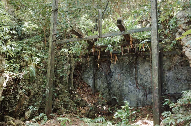
Fig. 22 – Remnants of the former loading facilities on the northeastern coastline of Angaur, built by the DSPAG around 1910 to enable loading under all weather conditions.
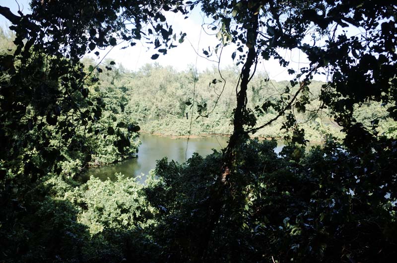
Fig. 23 – The former mining pits in the center of Angaur have formed a series of brackish ponds. The entire surface level of the island has been dropped by approximately thirty meters in this area as a result of phosphate mining.
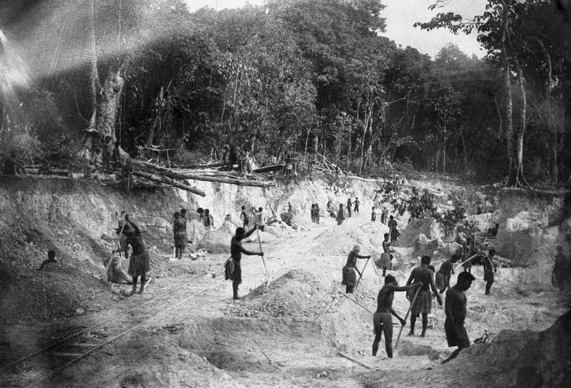
Fig. 24 – Indentured Caroline Islander laborers mining phosphate on Angaur using hand tools, c.1909. A tramway runs through the pit, connecting the mine to the processing facilities on the coast. Source: Deutsches Bundesarchiv, Sammlung Heinrich Hagedorn, Bild 223-153.
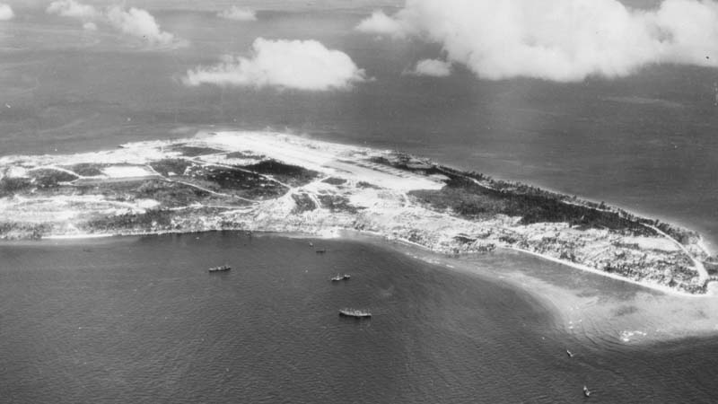
Fig. 25 – Aerial view of Angaur from the west. Apart from the airstrip, located at the top of the image, the white areas indicate phosphate mining sites. The major mines on the island are visible to the left of the image. A string of strip mines runs along the length of the runway. Source: US National Archives, Caroline Islands, 1944, 204969950.
Initially, during the period of the DPSAG, shallow pit mining was undertaken by hand using pickaxes and shovels, used to peel back the topsoil of the forest to reveal the reddish-brown phosphate it concealed (figure 24). Ultimately, however, manual methods gave way to floating mechanical dredges—first employed by the Japanese during the inter-war period—that drained the existing swamps to access the blankets of white phosphate beneath. The mechanical excavations eventually extended below sea level and, by the 1950s, Angaur’s freshwater supply and agricultural land were contaminated by salt water that had entered from below, through the island’s fissured rock. 22 I imagined the vast volumes of missing matter—long since dispersed across fields in Germany, Japan, Australia and New Zealand as superphosphate—trying to reinsert it all at once into the landform before me using my mind’s eye. The scale of extraction was somehow inconceivable yet still more immediate than the historical record with which I was familiar: tabulations of annual phosphate exports in company reports; photographs of laborers working in the pits, beleaguered by heat and dust; an aerial view from World War Two, the various mining sites clearly visible after American bombs had razed the island’s vegetation to the ground (figure 25). As I had been at Tocal, Dookie and across the Wimmera, in Liverpool, Reading, London, Hamburg and Bremen, and on Nauru and Christmas Island, once again I was absorbed by the vastness of the geography of superphosphate and the diverse forms of violence upon which its production relied.
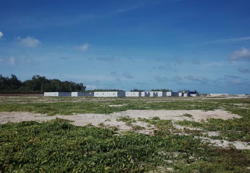
Fig. 26 – The surveillance station currently being constructed adjacent to the landing strip on Angaur as part of the US Air Domain Awareness Program.
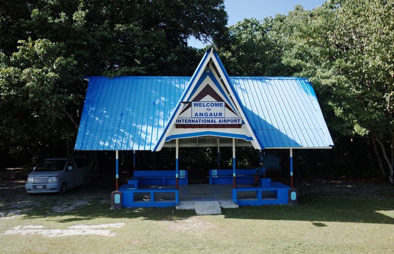
Fig. 27 – The passenger terminal at Angaur International Airport.
Seeing the surface of the ponds ripple in the wind, Michael suggested that we return to the boat before the weather deteriorated further. We rounded the western tip of the island, passing the Japanese-built airstrip and the American surveillance station currently under construction as part of the Air Domain Awareness program (figure 26). The wind was blowing hard now and the sea looked monstrous beyond the inner reef. The road ran southwest through former phosphate pits before pivoting north, past the airport terminal and an abandoned US Coast Guard station, towards the boat harbor (figure 27). The captain was waiting for us, taking a nap under a tree as the deckhand prepared the boat for our passage back to Koror. I informed him of the conditions on the exposed side of the island and asked if he knew what the weather prediction was for the afternoon. He replied that, as a rule, he never checked the forecast “because you’ve got to go through it anyway, so what’s the point?” I kept my thoughts on this philosophy to myself and thanked Michael for his hospitality before—somewhat reluctantly—climbing aboard.
It took us no less than twenty excruciating minutes to make it out of the harbor. The swell had picked up dramatically since our arrival, leaving very few opportunities for the captain to pass through the breakers without risking becoming swamped. I clung to the antique lifejacket I had been given, its frayed edges and loose fit testing my confidence in its utility. As we waited, I untied one of the inflatable fenders attached to the stern of the boat in case I was going to require additional buoyancy. The captain chose a narrow window between sets of waves and ploughed through the rising surf, launching us off the face of a final wave into the safety of deeper water. His unbridled celebrations at having made it through unscathed didn’t exactly fill me with confidence, but I buried that line of thought and tried to stay in the present moment. “I told you that thing was pointless,” he boomed, nodding at my bright orange lifejacket. “Nicely done,” I replied, terror and relief mixing with antipathy behind an ambivalent smile.
Things only got worse. For reasons that still escape me, the captain chose to navigate around the southern tip of Angaur before leading us north into an aggressive head sea on the western side of the island, directly into the bellowing wind. Had we stayed on the eastern side and headed north immediately, our course would have kept us in the lee of Angaur until we reached the calmer water offshore. Instead, the boat, its entire cabin wobbling as each wave shuddered through the hull, was slapped and rolled around for the next hour. Our progress was so constrained by the conditions that I began to question whether we had enough daylight left to make it back before dark. As we reached the water off the northern cliffs of Angaur—more or less where we had brought in the lures on the way over—the sea state deteriorated into something I never wish to experience again. Two swells moving in opposite directions—one groundswell, one wind-driven—coincided with one another to form steep wedges of water that shot up at random before crumbling into powerful whitecaps. The tallest of these wedges towered above us at around eight meters—the length of the boat—requiring the captain to slowly idle up the face of each wave before accelerating at the top to avoid being pushed backwards and capsizing. This meant that we launched off every wave vertically, falling eight meters from its lip into its trough, the two outboard engines momentarily disappearing underwater upon landing. Each time, I would turn to check the engines were still running when they resurfaced, the view of the swell crashing into Angaur’s cliffs visible in the background. At one stage, my watch lit up: my heartrate was so high and our progress so slow that it thought I was out swimming and wanted to know whether it should be recording my exercise. We proceeded in this fashion for what felt like forever, Peleliu refusing to draw closer as we bucked and battled the swell. The deckhand had withdrawn into himself entirely and was staring towards Peleliu in silence, disassociating from his surroundings as water washed over the gunwales, sloshing around the bilge. Thirty minutes after passing the cliffs, having made no visible progress, I asked the captain whether we were going to be ok or if we needed to call for assistance. “Oh, do you want to drive the boat?” was his reply, retrieving a flare gun from his bag as he spoke. “You need to learn to respect the ocean,” he added a few minutes later, unprovoked, the ice box strapped to the bow becoming dislodged as another wave rolled the boat onto its side. “Mayday! Mayday!” he screamed, pretending to hold a radio. He looked at me and laughed. I fixed my gaze on Peleliu and, for a third time that day, focused on my breathing.
Suffice to say, we made it back intact and I’m writing this report in my hotel room in Koror. We arrived in the rain after dark, the captain’s family lining the dock at the marina, concerned for his safety. Unlike him, they had checked the forecast and knew the risks he had taken. I was invited to dinner at a raucous bar and grill and we discussed other near-death experiences he had survived over the years. I felt vindicated, the topic of conversation an implicit concession that he had shared my concerns during the crossing after all. I don’t remember much else from that evening other than the sensation of wave after wave of relief passing through my body, the last of which struck as I finally lay down to sleep in the early hours of the morning. The next day, I battled two hangovers simultaneously: the first, induced by the celebration of our survival; the second, the emotional comedown from the precarious passage. I walked around Koror in a fog, the overcast sky and oppressive humidity not helping with my recovery. Still, it felt good to be alive and there was much I was yet to see. I visited the surreal Capitol of Palau in Ngerulmud, an early-2000s apparition of the United States Capitol, adorned with cosmological motifs from the period of Palau’s creation (figure 28). I tracked down the administrative buildings of the Nanyocho (South Seas Bureau) from the period of Japanese rule over the Marshall Islands, Caroline Islands and Northern Mariana Islands (figure 29). And I visited the Belau National Museum, its archives housed in the former meteorological observatory of the South Seas Bureau.
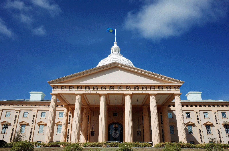
Fig. 28 – The Capitol of Palau in Ngerulmud district, designed by Joseph Farrell. A strange sight on a small tropical island.
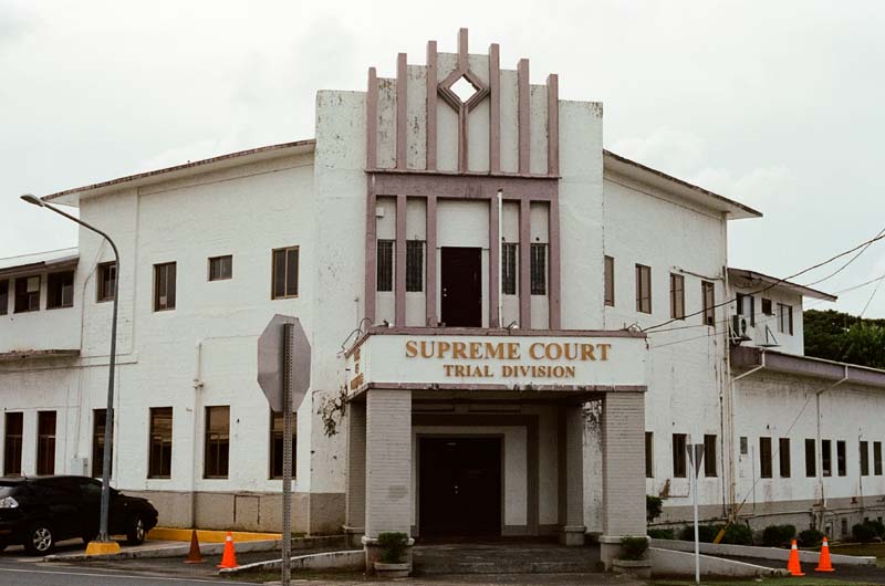
Fig. 29 – The former Koror headquarters of Japan’s inter-war South Seas Bureau government.
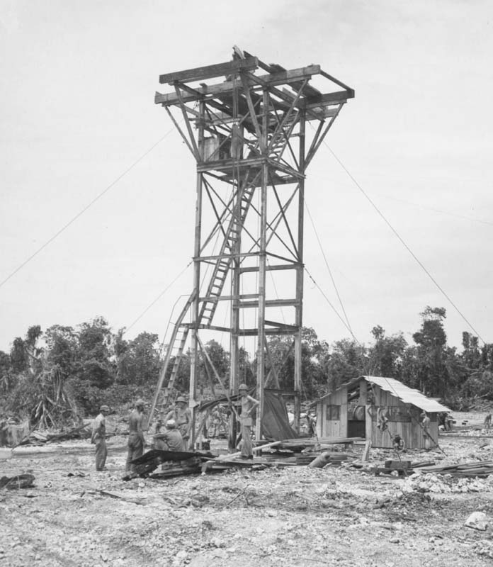
Fig. 30 – The original caption reads: “7th Air Force Engineers using steel girders taken from Japanese mill, in construction of control tower on Angaur Island, Caroline Islands, 6 November 1944.” Source: US National Archives, Caroline Islands, 1944, 204970295.
I also spent a day reviewing the photos I had taken on Angaur in an attempt to distinguish the different historical periods of the structures and sites I had visited with Michael. This is when I came across the tranche of photographs from World War Two referred to above. I became interested in one photograph in particular: an unusual control tower, built to manage air traffic on Angaur once it had fallen under US control (figure 30). The caption indicated that it had been constructed by Air Force engineers using steel repurposed from the phosphate mill on the island. It struck me that this tower somehow embodied the material continuity of imperialism in Palau: steel originally manufactured in Hamburg to construct the Gute Hoffnungshütte on Angaur during the period of German colonial rule, extended by the Nan’yo Kohatsu when Palau fell within the South Seas Mandate, and incorporated into one of the earliest structures of the American occupation of Palau, under which phosphate mining would continue until the mid-1950s. But where continuity implies linearity—an unbroken sequence of events—it fails to capture the political ruptures and breaches that characterize Palau’s modern history across Spanish then German then Japanese then American rule. In this sense, the tower perhaps more accurately embodied the pervasive logic of extractivism, registering the administrative layering of imperialism and the staccato bureaucratization of political authority on Angaur, but also the continuity of the wider hegemonic order of global capitalism in which phosphate extraction was always rooted—from what Karl Marx referred to in the nineteenth century as a metabolic rift, to its deepening under industrial conditions through the processes Marion W. Dixon terms “chemification.” 23 By the time mining was discontinued on Angaur under the US administration in 1955, close to 3.75 million tons of phosphate ore had been exported from the island—representing around one percent of global annual phosphate production—used to manufacture in excess of 7 million tons of superphosphate fertilizer at ports around the world. 24
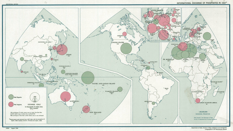
Fig. 31 – Map of the global phosphate trade in 1937. The green circles indicate net exports of phosphates. The pink circles indicate net imports. Australia and New Zealand were among the world’s largest importers of phosphate, almost exclusively from the Indo-Pacific. Source: International Exchange of Phosphates in 1937, Department of State, Division of Map Intelligence and Cartography, 1926, US National Archives, 159081051.
Although it overwhelmingly fueled the industrialization of Japanese agriculture, the phosphate industry on Angaur was also entangled with antipodean settler colonialism. One third of the almost 200 tons of material exported from the island prior to World War One was shipped to Australia and New Zealand 25—a period during which the former country became the highest consumer of superphosphate of all land-abundant economies, including the US, Russia, and Canada (figure 31). 26 In this way, the pre-war activities of the German-run DSPAG on Angaur complemented similar operations on Nauru and Banaba (Anglo-German), Makatea (French) and Christmas Island (British) in tethering unexploited phosphate reserves to Australia’s rapidly expanding wheatbelts. The inter- and intra-imperial character of the Indo-Pacific phosphate industry before the war did not preclude its value for the economic development of the Australian colonies; rather, the various colonial governments’ liberal attitudes towards national and imperial interests largely left the question of the flow of phosphate to the vicissitudes of the global market, which Australia worked to its benefit. This changed after the war through the reapportioning of Pacific territories by the League of Nations, which saw a boisterous Australia vie for a sphere of influence in its region—especially in relation to the known phosphate deposits—by deploying a white supremacist logic in which white possession of Australia depended on white possession in the Pacific and vice versa. 27 Later, when the US enabled Japan to work the Angaur deposits to reduce its post-war food deficit, Australian anxieties about non-white incursions into its sphere of influence again came to the fore. 28 The history of phosphate imperialism on Angaur is therefore not only entangled with Indigenous dispossession in Australia but also the particular brand of racial capitalism it practiced as a regional power, both within and beyond its sovereign borders.
Close to four decades of intensive phosphate mining and aerial bombardments left more than half the surface of Angaur unusable for any human purpose. 29 The island’s taro patches, upon which social status and political structures were based, had been destroyed, relocated and encroached upon countless times under successive foreign occupations. The Angaurese had been shifted around the island in a similar fashion: to make way for mining and conflict between competing foreign powers, including to Babeldaob, the northernmost island in the Palau archipelago. Consistently denied land rights, inadequately compensated, repeatedly excluded from the economic opportunities presented by the phosphate industry, and continually subjected to arbitrary governmental regimes, the community on Angaur practiced a patient and sustained resistance, ceaselessly advocating for their sovereignty and the protection of their livelihoods. “We, the Angaur people,” wrote Chief Uherbelau to the US administration in 1947, “are disturbed about these things, and our heart weeps to think of them. We are most disturbed over the problem of what will become of our people when this little island that belongs to us has all been mined.” 30 We now occupy that future. As the US returns to Angaur to ramp-up its surveillance of China, and Australia “reengages with the Pacific” by delivering energy and telecommunications infrastructure throughout the archipelago, it is difficult not to see these projects as yet another layer of imperialism in Palau through which foreign powers are again attempting to consolidate their positions of influence within the wider global order.
1 Jay Dobbin and Francis X. Hezel, “The Religion of Palau,” in Summoning the Powers Beyond: Traditional Religions in Micronesia (Honolulu, HI: University of Hawai'i Press, 2011), 166–67.
2 Jolie Liston and Melson Miko, “Oral tradition and archaeology: Palau’s earth architecture,” in Jolie Liston, Geoffrey Clark and Dwight Alexander, eds., Pacific Island Heritage: Archaeology, Identity & Community (Canberra: ANU Press, 2011), 185–86.
3 John Rodgers, “Phosphate Deposits of the Former Japanese Islands in the Pacific: A Reconnaissance Report,” Economic Geology 43 (1948), 406.
4 Jean Fritsch, The Manufacture of Chemical Manures (London: Greenwood & Son, 1911).
5 The signatories listed in the contract are transliterated as follows: Ugerbalau, Ungerbunch, Gagelbai, Riguchel, Midechulsch, Gaithan, Thalowak and Guang. Contract of Acquisition, Imperial District Administrator Fritz and Director Schönian of Angaur, 20 November 1909, University of Hawai'i Library, A21.
6 Parts of the letter are cited in Cecilia Wahl, Number One Pacific Island (Bloomington, IN: Woodcrest, 2000), 118–20.
7 Olsudong and Blaiyok, “Preliminary Report,” 12.
8 Augustin Krämer, Palau, vol. 1 (Hamburg: L. Friederichsen & Co., 1917), 159.
9 Francis X. Hezel, Strangers in Their Own Land: A Century of Colonial Rule in the Caroline and Marshall Islands (Honolulu, HI: University of Hawai'i Press, 1995), 122.
10 Bericht über die bei der Deutsche Südseephosphat Aktiengesellschaft vorgenommene Revision, Bundesarchiv, 6 May, 1909, R1001/2462, 35.
11 Olsudong and Blaiyok, “Preliminary Report,” 13.
12 David Hanlon, Remaking Micronesia: Discourses Over Development in A Pacific Territory, 1944–1982 (Honolulu, HI: University of Hawai'i Press, 1998), 63.
13 “Gewinn- und Verlust-Rechnung per 31. Dezember 1910,” Geschäfts-Bericht der Deutschen Südseephosphat-Aktiengesellschaft in Bremen für das Geschäftsjahr 1910, Leibniz Informationszentrum Wirtschaft, 45933.
14 Anneliese Scharpenberg and Hartmut Müller, “Die Deutsche Südseephosphat-Aktiengesellschaft Bremen,” Bremisches Jahrbuch 55 (1977), 165–66.
15 Rodgers, “Phosphate Deposits of the Former Japanese Islands in the Pacific,” 401.
16 Not his real name.
17 Frank E. Poirier and Euclid O. Smith, “The Crab-Eating Macaques (Macaca fascicular is) of Angaur Island, Palau, Micronesia,” Folia Primatologica 22 (1974): 258–306.
18 Rita Olsudong and Vince Blaiyok, “Preliminary Report Reconnaissance Survey of Archaeological Sites in Angaur State,” Division of Cultural Affairs, Ministry of Community and Cultural Affairs, Republic of Palau, October 1996, 16.
19 Olsudong and Blaiyok, “Preliminary Report,” 21.
20 Mark R. Peattie, Nanyo: The Rise and Fall of the Japanese in Micronesia, 1885–1945 (Honolulu, HI: University of Hawai'i Press, 1988), 126–27. See also Yuta Sumi, “The Use of Accounting Information for Factory Closure and Income Creation: The Case of the South Seas Development Company, 1937–1944,” Accounting History Review 27, no. 2 (2017): 143–75.
21 Douglas Osborne, The Archaeology of the Palau Islands: An Intensive Survey, Bernice P. Bishop Museum Bulletin no. 230 (Honolulu, HI: Bishop Museum Press, 1966).
22 Chester K. Wentworth, Arnold C. Mason and Dan A. Davis, “Salt-water Encroachment as Induced by Sea-level Excavation on Angaur Island,” Economic Geology 50 (1955): 669–80.
23 Catherine Alexander, Katerina Teaiwa and Andreas Neef, “Phosphate Mining in Distant Places: The Dark Side of New Zealand’s Agricultural Economic Success,” in Andreas Neef, Chanrith Ngin, Tsegaye Moreda and Sharlene Mollett (eds.), Routledge Handbook of Global Land and Resource Grabbing (London: Routledge, 2023), 261. See also Jasper Ludewig, “On Accumulation: Phosphorous and the Global Metabolic Rift,” SAH Blog, October 3, 2023.
24 Ted Arnow, Effects of Phosphate Mining on the Ground Water of Angaur, Palau Islands Trust Territory of the Pacific Islands, Geological Survey Water-Supply Paper 1608-A (Washington, D.C.: United States Government Printing Office, 1961), 14.
25 Michael Hofmann, Deutsche Kolonialarchitektur in China und der Südsee (Petersberg, Hesse: Michael Imhof Verlag, 2016), 178.
26 Derek Byerlee, “The Super State: The Political Economy of Phosphate Fertilizer Use in South Australia, 1880–1940,” Jahrbuch für Wirtschaftsgeschichte/Economic History Yearbook 62, no. 1 (2021), 100.
27 Priya Chacko, “Racial Capitalism and Spheres of Influence: Australian Assertions of White Possession in the Pacific,” Political Geography 105 (2023), 4.
28 “Australian Protest over Jap. Phosphate Workings on Angaur,” Queensland Times, June 27 (1947), 1. See also: Christopher Michael Aldous, “Replenishing the Soil: Food, Fertiliser and Soil Science in Occupied Japan (1945–52),” Environment and History 28, no. 2 (2022): 311–37.
29 Hanlon, Remaking Micronesia, 66–68.
30 Cited in Wahl, Number One Pacific Island, 120.